Bald Mountain (Townsend)
Mileage: 3.80 miles
Elevation gain: 1450 feet
Trails used: Bald Mountain Trail.
Highlight(s): former fire tower peak, views from the summit of Bald Mountain.
I have compiled a list of fire towers in Vermont, so I decided to check this peak out as it once held a fire tower on its summit. It was going to be quite a drive though and the weather was going to be iffy with snow showers moving in at some point in the day, and a nice breeze blowing in some cooler air. I would still make a good time of it. It was fun trying to figure out how to get to Townsend State Forest but once I did find it, it was closed for the season so I had to park outside the gate for a short hike to the trailhead.
Bald Mountain is located in Townsend, Vermont and also in Townsend State Forest. The Bald Mountain Trail starts in Townsend State Park, which has camping areas and picnicking areas available (in season). The Bald Mountain Trail goes to the summit of Bald Mountain, where there are several vistas as well as the remains of an old fire tower that once stood on the summit.
Townsend State Forest Recreational Trail
Townsend State Park
The Townsend State Forest & Park is closed for the season, as evidenced by the closed gate. So I parked the car off of State Forest Road and headed in.

The start of the Bald Mountain Trail starts almost directly across from the State Forest Ranger Station. In season, there is a fee to hike the Bald Mount Trail.

You cross a bridge over Negro Brook and begin the hike on an old truck road built by the Civilian Conservation Corps (CCC).

You parallel Negro Brook, and its neat chutes and cascades, as you ascend the blue blazed Bald Mountain Trail.


After an old road junction and after crossing Negro Brook, I started to climb through the hardwoods. You have to pay attention to the blazes in this area.

The Bald Mountain Trail starts a steep climb on an old road as you climb towards the summit of Bald Mountain.

The nicest section of the Bald Mountain Trail just below the summit of Bald Mountain.

Views towards Stratton Mountain (in the clouds) from the summit area of Bald Mountain.

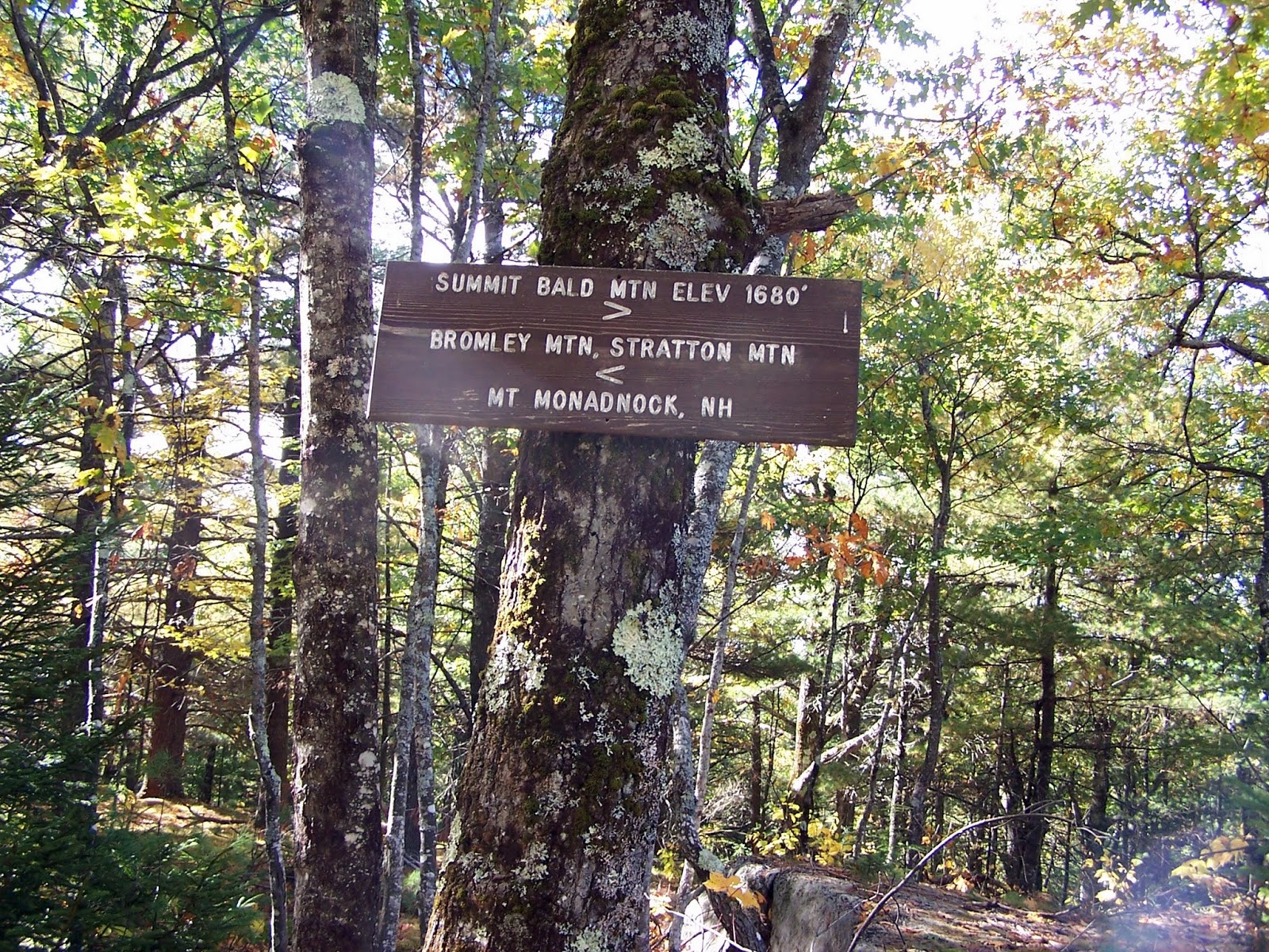
The summit sign on Bald Mountain (elevation: 1680 feet), which is slightly off of the high point (which is near the fire tower remains). To the right, views towards Stratton Mountain and to the left, Mount Monadnock in New Hampshire.
These bolts denote where the fire tower footings once stood. The fire tower on the summit of Bald Mountain was removed in the 1940's.


The other vista from the summit of Bald Mountain looking towards Mount Monadnock and Gap Mountain in New Hampshire.


Heading back down the old road section of the Bald Mountain Trail on the opposite side of Negro Brook. The clouds started moving in around this time.

This old road (and section of the Bald Mount Trail) has heavy erosion from a hurricane in the 1930s. I am near the Negro Brook bridge crossing.

The ranger station for Townsend State Park. This is where you would go to pay the fee to hike on the Bald Mountain Trail.

I only passed two people the whole hike (a couple I met coming off the summit as I was going up). I managed to pass them on the way back to the car. My next hike I would have to backtrack through downtown Townsend, where they were having a pumpkin festival, and then head down Route 30. From there, it was a nice winding drive up Putney Mountain Road which was also bumpy in sections.
Putney Mountain
Mileage: 1.2 miles
Elevation gain: 210 feet
Trails used: Ridge Line Trail.
Highlight(s): views from the summit area of Putney Mountain, bird watching area.
I can't remember where I saw a trip report for this hike but it would be quick and with possible weather moving in, quick was good. It was just a matter of finding the mountain road that goes up to the trailhead, which wasn't an issue. It was at the height of land off of Putney Mountain Road, which is closed in winter. When I arrived at the trailhead, I was unprepared for just how popular this small peak would be.
Putney Mountain is located in Brookline, Vermont and in Putney Town Forest. There are several trails that you can use to reach the summit of Putney Mountain. Once on the summit, there are several vistas looking into New Hampshire and western Vermont. People also do bird watching as evidenced by numerous people sitting in lawn chairs with binoculars and cameras looking to the sky.
Putney Mountain Trail Guide
Putney Mountain Association Windmill Ridge Nature Reserve and Trail


I quickly reversed course and headed back to the car. I noticed some light snow flakes falling as I left the summit of Putney Mountain and the wind was blowing quite steadily. I contemplated doing another hike but as I headed up towards Ludlow, Vermont I drove through my first snow of the year which was coming down at a fairly good clip. That effectively killed any desire to hike anymore today so I headed home.
Putney Mountain was the easier of the two hikes, and the one with better view potential. Bald Mountain offers a nice mild walk in the woods to the site of an old fire tower which resided on its summit, as well as 2 viewpoints with okay views.
I can't remember where I saw a trip report for this hike but it would be quick and with possible weather moving in, quick was good. It was just a matter of finding the mountain road that goes up to the trailhead, which wasn't an issue. It was at the height of land off of Putney Mountain Road, which is closed in winter. When I arrived at the trailhead, I was unprepared for just how popular this small peak would be.
Putney Mountain is located in Brookline, Vermont and in Putney Town Forest. There are several trails that you can use to reach the summit of Putney Mountain. Once on the summit, there are several vistas looking into New Hampshire and western Vermont. People also do bird watching as evidenced by numerous people sitting in lawn chairs with binoculars and cameras looking to the sky.
Putney Mountain Trail Guide
Putney Mountain Association Windmill Ridge Nature Reserve and Trail
The Putney Mountain Trailhead kiosk which is off of Putney Mountain Road. There is a nice sized parking area for a decent amount of vehicles. Unfortunately, in winter Putney Mountain Road is closed.

I took the Ridgeline Trail to the summit of Putney Mountain and then back to the car.

A nice section of woods along the Ridgeline Trail. It was a quick hike to the summit and very little elevation gain.

The views looking towards Stratton Mountain from the summit area of Putney Mountain.

The views looking towards Mount Monadnock and Gap Mountain in New Hampshire from the summit of Putney Mountain (elevation: 1673 feet).

The views looking towards Mount Snow and Haystack Mountain (ski areas) from the summit of Putney Mountain. The guys sitting on the summit in the center of the picture are doing some bird watching (mainly hawks migrating currently).

I quickly reversed course and headed back to the car. I noticed some light snow flakes falling as I left the summit of Putney Mountain and the wind was blowing quite steadily. I contemplated doing another hike but as I headed up towards Ludlow, Vermont I drove through my first snow of the year which was coming down at a fairly good clip. That effectively killed any desire to hike anymore today so I headed home.
Putney Mountain was the easier of the two hikes, and the one with better view potential. Bald Mountain offers a nice mild walk in the woods to the site of an old fire tower which resided on its summit, as well as 2 viewpoints with okay views.
No comments:
Post a Comment