Tentative plans were made (earlier in the week) for Saturday to be our day to hike, but at the time it would only be Kris and I. Since this was Kris' idea I pretty much let him decide what he wanted to do, as he is working on the New Hampshire Two Hundred Highest List and has quite a few peaks he still needed to do. We threw ideas back and forth and eventually I was messaging Brian (who had planned to do some views type hikes in Vermont at first), and pretty soon I was bouncing ideas back and forth between the two. The way Kris and I figured it, we could always change our minds as we drove north, as the day was set to provide us warm temperatures and nice views. Eventually, plans were set in stone and we were ready for the hike Saturday.
Sugarloaf Mountain
Mileage: 4.20 miles
Elevation gain: 2130 feet
Trails/Route used: Sugarloaf Mountain Trail.
Highlights(s): Former fire tower peak, almost 360 degree views from the summit of Sugarloaf Mountain.
Type of Hike: Trailed.
Views: Yes
Type of Hike: Trailed.
Views: Yes
Brian decided he would be joining us for today's hike so the decision was to meet at the exit 17 park n' ride at seven a.m. We would pile all of our gear in one car and make the trip north for a nice day hike (or two). I started the day off on the right note, as I left a container of fruit in my car from the prior weeks hike, and with the heat of the week, the fruit was a bit ripe (fuzzy and smelly as well). I had no clue what the smell was until i got to the park n' ride. Once I figured out what it was, I disposed of the fruit and we put all of our stuff in Kris' SUV and made our way north.
Originally Kris wanted to do South Percy and North Percy but we decided on a peak that was nearby: Sugarloaf Mountain, which is located in Stratford, New Hampshire. Sugarloaf Mountain is also the highest point in Stratford. Personally, this would be my third time on Sugarloaf Mountain (the first time with Mike, Brian and Joe as we bushwhacked over to Castle Mountain and West Castle, and then with Desi a year later), although each time I have gotten decent views from the summit. This time, it would be Sugarloaf Mountain by itself as Kris had not hiked in awhile thus saving Gore and West Castle for later journeys.
We made the drive to Nash Stream Road fairly quickly and when we passed by the Percy Peaks Trail head area, there were already a few people out hiking so it was possible to be a busy day in the area. Once at the trail head parking area, we geared up and made the steep climb towards the summit of Sugarloaf Mountain.
*Sugarloaf Mountain is on the New Hampshire One Hundred Highest List, New Hampshire Two Hundred Highest List, New Hampshire 3K List and New Hampshire 52WAV (With a View).*
We parked at this cabin just off of Nash Stream Road, taking care not to block the driveway. You need to walk past the cabin to get to the actual trail. Brian is telling us to hurry up before we start our hike towards the summit of Sugarloaf Mountain.

The water was flowing in this little stream despite the lack of rain lately.

The Sugarloaf Mountain Trail is steady and steep as it makes its way towards the summit of Sugarloaf Mountain.

You pass the remains of the old fire wardens cabin as you make your last push up towards the summit of Sugarloaf Mountain.

As we climbed past the old fire wardens cabin site, we looked back to get a taste of the views to come from the summit of Sugarloaf Mountain.

Only a few more feet and we will make it to the summit of Sugarloaf Mountain.

The views from ledges below the summit of Sugarloaf Mountain looking towards Teapot Mountain, Goback and Savage Mountain-East Peak, with East Mountain, Burke Mountain and Umpire Mountain in the background.

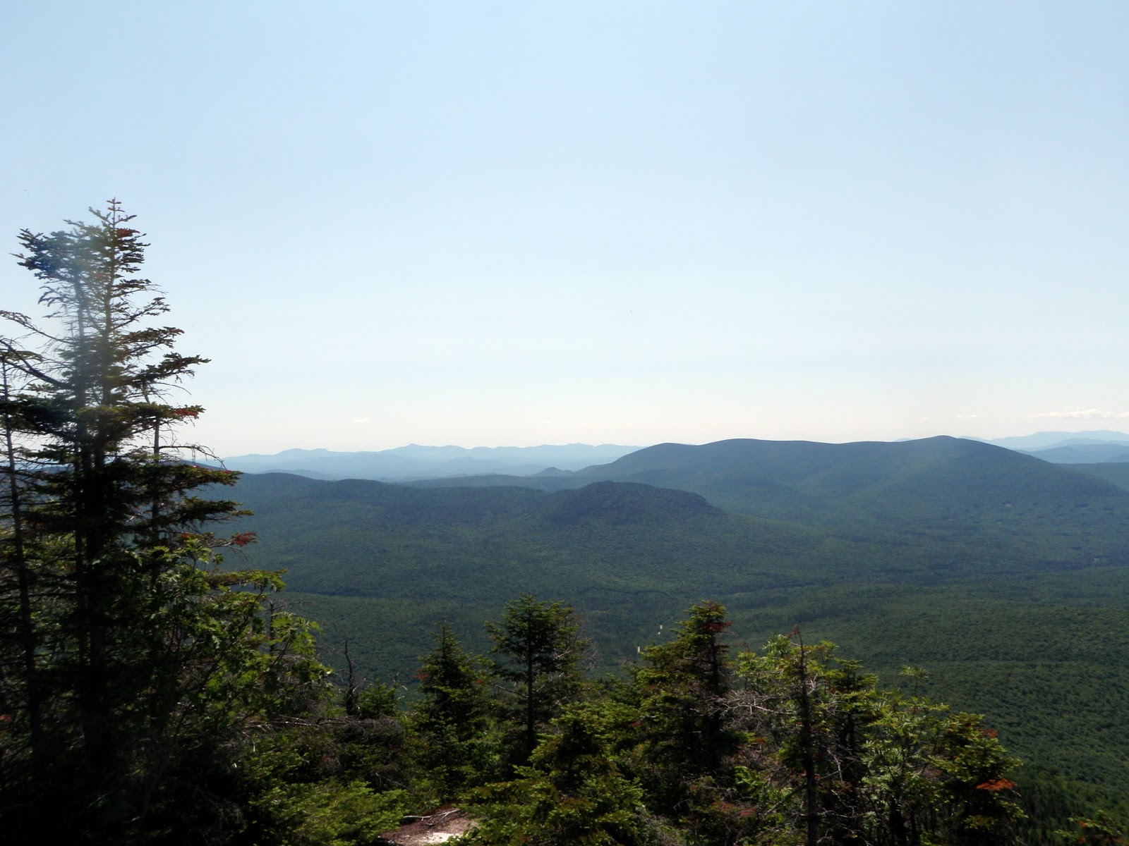
The views south from the summit of Sugarloaf Mountain looking towards nearby Stratford Mountain, North Percy Peak, South Percy Peak, the Pilot Range, Mount Washington and the Presidential Range, Mount Cabot, the Bulge, then Horn, North Twin, South Twin, Mount Garfield and Franconia Ridge

The views looking southeast from the summit of Sugarloaf Mountain towards Whitcomb Mountain-West Peak and Long Mountain. The Mahoosuc Mountain Range is in the background: Mount Carlo, Goose Eye Mountain, Fulling Mill Mountain, Old Speck and the Baldpates. The Carter Range is to the right of Long Mountain.
The views looking south from the summit of Sugarloaf Mountain towards North Percy Peak, South Percy Peak, the Horn, the Bulge, and Mount Cabot. In the background, the views of Mount Washington, Mount Adams, Mount Madison, Mount Monroe, Carter Notch and Carter Dome rule the picture.

This old stove was on some lower ledges on the summit of Sugarloaf Mountain. I can't remember if it was there the two times I was there before, or if someone hauled it up here.

Its nice to sit on a summit on a day like this, and with super nice views.

It would have been a perfect day if not for the bugs, which made sitting up on the summit of Sugarloaf Mountain not so much fun. It was nice that we had a slight breeze, though.

The high point for Sugarloaf Mountain (elevation 3701 feet).

We sat on the summit for awhile to unwind after the steep climb, and to relax before we headed back down. The views from the summit have yet to disappoint, like the two other times I have been here, and today did not disappoint. The only negative was the black flies that buzzed us constantly, causing Brian and I to don our bug net hats and Kris his soft shell jacket. Eventually we decided to make the steep descent back down and made it in good time back to Kris' car, only passing two other hikers heading up to the summit area.
Devils Slide
Mileage: 1.85 miles
Elevation gain: 1085 feet
Trails used: bushwhack, unknown trail.
Highlight(s): views from ledges below summit of Devils Slide.
Type of Hike: Trailed, bushwhack.
Views: Yes
Type of Hike: Trailed, bushwhack.
Views: Yes
I had brought along a book "Explorers Guide 50 Hikes North of the White Mountains written by Kim Nilsen" and found this next hike in one of the chapters, so we thought "why not?". It didn't look that bad and even though were pretty spent from the steep descent off of Sugarloaf Mountain, we figured we had time and energy (or so we thought) to do another "easy" hike. Devils Slide is located in Stark, New Hampshire and it seemed like we were almost right around the corner from Sugarloaf Mountain as Kris made the quick drive into Stark.
The directions in the book were a bit confusing (as we would come to find out later). We even had to stop and ask a local resident outside of their house where the trail started and we were told that it was a short ways down the road. I think the people asked figured we were going to try and drive up to the summit in Kris' SUV as i was told "we wouldn't make it up the road in that car". It seemed like we drove down the road several times, passing the houses in the area over and over before we stopped and found an old road of some sort heading into the woods. Kris parked, we geared up, and then headed into the woods hoping to have some views from the cliffs that are on the east side of Devils Slide.


We followed the un-named trail a short ways but noticed it was heading off in the opposite direction of the car, so we ended up bushwhacking back down to the road and walking through the property of the people we initially asked for directions, and then short road walk back to the car.
On the way back out, we managed to find where the trail actually started (exactly where the book says it is, but the yellow blaze is very hard to notice if you are not looking for it). The trail would actually make things a lot easier if you aren't too fond of bushwhacking.
Overall, the views from Sugarloaf Mountain was the highlight of the day. We thought there would be decent enough views from the ledges on Devils Cliff but for the effort, you can find them on other peaks in the area like Sugarloaf Mountain or North Percy Peak and South Percy Peak. Still, despite the bugs, it was a nice day to be out hiking with Brian and Kris.
The directions in the book were a bit confusing (as we would come to find out later). We even had to stop and ask a local resident outside of their house where the trail started and we were told that it was a short ways down the road. I think the people asked figured we were going to try and drive up to the summit in Kris' SUV as i was told "we wouldn't make it up the road in that car". It seemed like we drove down the road several times, passing the houses in the area over and over before we stopped and found an old road of some sort heading into the woods. Kris parked, we geared up, and then headed into the woods hoping to have some views from the cliffs that are on the east side of Devils Slide.
We parked on the side of Northside Road after getting directions by some locals who obviously were not too sure where the actual trail started. We went anyways.

The dirt road disappeared not long after we started up it so we bushwhacked through mostly open woods, and rather steeply at times, towards the summit of Devils Slide.

Eventually we hit this yellow blazed trail, which we took to get near the ledges below the summit of Devils Slide.

The views from ledges below the summit of Devils Slide looking towards Mill Mountain and Stark, New Hampshire.

The wooded, view-less high point for Devils Slide (elevation: 1580 feet).

I walked past the summit of Devils Slide, along a herd path that ran towards another ledge with views looking towards Square Mountain, Rogers Ledge-North Peak, and Unknown Pond Peak.

This short road walk back to Kris' car provided us this look towards South Percy Peak, as Brian admires it along the way.

We followed the un-named trail a short ways but noticed it was heading off in the opposite direction of the car, so we ended up bushwhacking back down to the road and walking through the property of the people we initially asked for directions, and then short road walk back to the car.
On the way back out, we managed to find where the trail actually started (exactly where the book says it is, but the yellow blaze is very hard to notice if you are not looking for it). The trail would actually make things a lot easier if you aren't too fond of bushwhacking.
Overall, the views from Sugarloaf Mountain was the highlight of the day. We thought there would be decent enough views from the ledges on Devils Cliff but for the effort, you can find them on other peaks in the area like Sugarloaf Mountain or North Percy Peak and South Percy Peak. Still, despite the bugs, it was a nice day to be out hiking with Brian and Kris.


