Saturday, May 30, 2015

Mount Tom (Woodstock,VT) - Morgan Peak (VT) - Saddle Mountain (VT): 5/30/2015

No real plans for Saturday so we went with the usual mix of looking at guide books, maps and various hiking books we brought along.  It is either a hit or miss proposition for us and doesn't leave us disappointed if we don't finish any peaks we plan.

It was supposed to be a nice day and it didn't disappoint.  It stayed sunny for the entire day with no rain which is  always nice when you do a mixture of trailed hikes and bushwhacks. Having wet pants and shoes all day is not fun.


Mount Tom 

Mileage: 4.35
Elevation gain: 1110 feet
Trails used: Faulkner Trail, Mount Tom Road, Billings Trail, North Peak Trail, bushwhack.
Highlight(s): switchback trails, decent views of the Woodstock area, easy to follow trails.


We found this hike in a guidebook that Brian brought along and it was along the way to some potential peaks we wanted to do.  The bonus: there are trails that we could use to reach various points in the park and the high point of Mount Tom.  We really didn't think this would take too long as it was lower level and all trail so that was a determining factor on why we picked it.  

Mount Tom is located in Woodstock, Vermont and also in Billings Park.  It is also included in the Marsh-Billings-Rockefeller National Historical Park.  There was also a ski area on Mount Tom until the early 80s.  For a map of the park go here.  The actual summit of Mount Tom is right off the North Peak Trail which curls around to the northwest.  We bushwhacked back to the Mount Tom Road since we weren't sure where the North Peak Trail came out.  


Brian doing his best Forrest Gump impression as he sits on a bench in Faulkner Park.


The kiosk on the Faulkner Trail side of Mount Tom, complete with hiking trail map and information on the area.


The Faulkner Trail starts out as a hard packed trail with many switchbacks so it easy access for many hikers.


Good thing the picture came out a bit blurry as this bridge troll is a terrible sight to see in real life.  Trust me.


There are quite a few trails that branch off of the Faulkner Trail (now more of a rocky, steeper hike) so the hiking possibilities are endless.


Views of nearby Baylies Hill in Woodstock from some ledges below the summit of Mount Tom.


Brian making his way up the steeper part of the Faulkner Trail as we make it up to some view points below the main summit of Mount Tom.


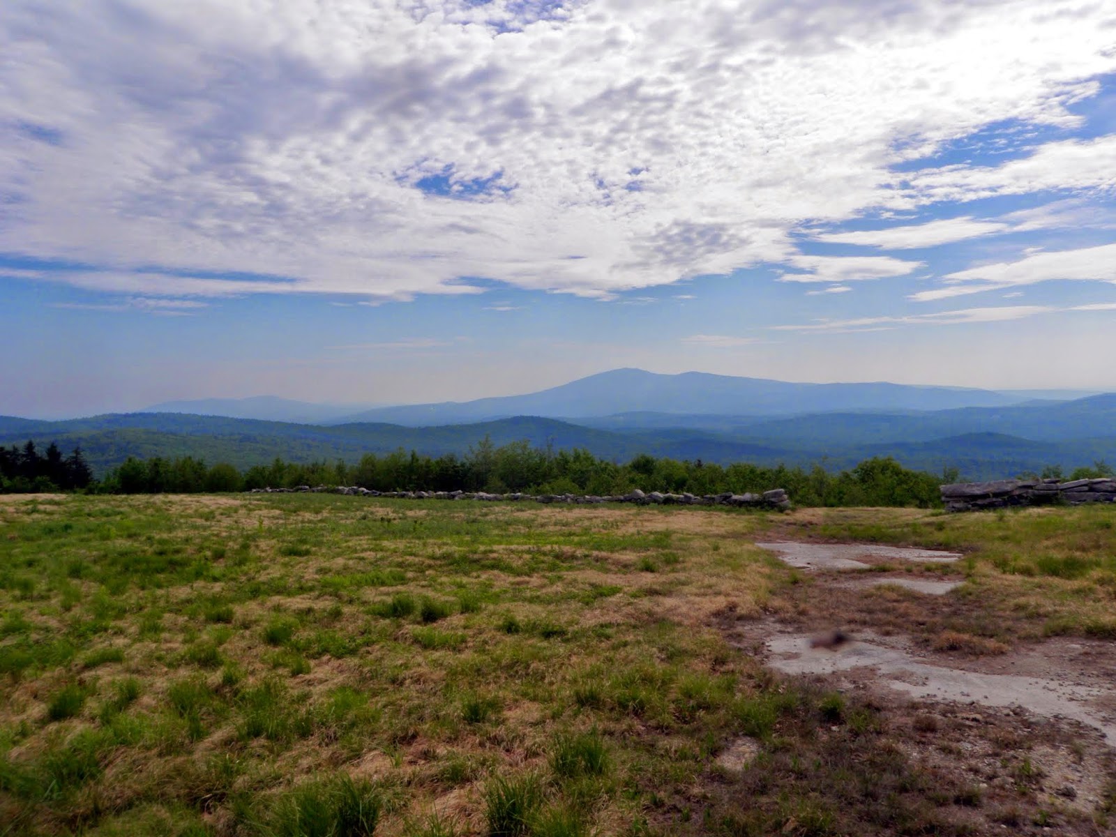
The views from the south peak of Mount Tom looking towards Mount Ascutney.  Also in view is the town of Woodstock, Vermont which is a nice quaint New England town.


Walking along the Mount Tom Road which is almost paved but hey, its a road so its easy to walk along.  


We took the Billings Trail up towards the summit area of Mount Tom, which was short but steep as it headed up.


The high point of Mount Tom (elevation: 1340 feet) which is right off the North Peak Trail.


More views looking south-southwest into Vermont from the south peak of Mount Tom and right along the Mount Tom Road.  There is a bench here so you can sit, relax and enjoy the views.  There are other trails around so you can make a full day of hiking here.


Once we were done, we backtracked to the car as fast as we could as we didn't expect this hike to last as long as it did.  Brian looked at maps and his guide books for other peaks that we could do as soon as we were in the car.  I wanted to do a bushwhack and one looked enticing and it was on the way to wherever we decided we were going.  It just meant even more driving and less hiking.


Morgan Peak

Mileage: 2.15
Elevation gain: 690 feet
Trails used: none.  Old woods road, snowmobile trail, bushwhack.
Highlight(s): nice woods, old logging roads, summit with register.


We drove down one forest road (Ranger Road) and made good time only to be stopped by a truck blocking the road while the occupants were removing an old tree from the road.  So we turned around and drove up Messer Hill Road where we parked at an old logging landing to attempt the hike up to Morgan Peak.

Morgan Peak is located in Bridgewater, Vermont and is just outside of the Calvin Coolidge State Forest.  There were old logging cuts from the logging landing area where we parked which we could use to get closer to the summit area of Morgan Peak.  One of the logging cuts was very trail-like and could possibly be used by snowmobiles in the winter.  There are no views from its wooded summit.


We noticed this large bear track as we headed up an old woods road towards the summit of Morgan Peak.


We followed old woods roads and logging roads to the summit of Morgan Peak, where there was a short bushwhack as we headed over several summit bumps.


Approaching the summit area of Morgan Peak. It got a little scrappy on the summit.


The summit jar on Morgan Peak (elevation: 2618 feet).  It was a pretty easy hike and bushwhack to get here and it was mainly a road walk.


As we headed down the old logging road, we noticed something in the woods and came upon this shelter.  No clue why it is here and I couldn't find anything online.  


Now what to do.  Do what we always resort to: look at the map, try and figure out what was nearby and go and try and hike it.  We thought about doing Shrewsbury Peak and Smith Peak but due to the time it would take to drive there and do both hikes, we decided on doing a hike to a peak that was along the Appalachian Trail/Long Trail.  It is unofficially named on the maps so we would call it Saddle Mountain (which is a mountain chain located to the east of where we were).


Saddle Mountain (unofficial name)

Mileage: 3.10
Elevation gain: 830 feet
Trails used: Appalachian Trail, Long Trail, bushwhack, old logging cut, recent logging cut.
Highlight(s): decent views from the summit, ATV/logging road to hike up.


This peak has no official name so on some maps it is called Saddle Mountain so that is what we went with.  We figured we could use a portion of the Long Trail/Appalachian Trail to get us closer to the summit with only a short, steep bushwhack.  It was pretty hot out so we were constantly using our spray bottles (a new addition to our summer hiking gear) to cool us off.  
Saddle Mountain is located in Shrewsbury, Vermont.  We did this as part trail hike and part bushwhack but we found out that you could use an recent logging cut that is now used by ATV's to reach the summit.  There are decent views from the summit of Saddle Mountain.


We parked at the Long Trail/Appalachian Trail crossing on Lottery Road.


We used the Long Trail/Appalachian Trail to get to the height of land where we would begin the bushwhack up to the summit of Saddle Mountain.  We lucked out by finding a snowmobile trail or old logging road that got us just below the summit.


It was a nice fern whack through this old logging area on the way to the summit.


Once we made it to the summit of Saddle Mountain (elevation: 2465 feet), we were pleasantly surprised to see it had views and a road leading up to it.  There was a few people on an ATV a few minutes before we reached the summit.


We could see the Dorset Mountains and Ludlow Mountain, home of the Okemo Ski Area from the summit area of Saddle Mountain.


There is this repeater station on the summit of Saddle Mountain for the town of Shrewsbury, Vermont.  There is even a wooden bench on the summit.


We found this old logging road that serves as the ATV access road to reach the summit of Saddle Mountain.  Funny thing is, we turned around at the logging landing at the bottom of thr ATV access road which we could have used to save ourselves time and a bushwhack.


At this point, we had looked at access for several other peaks but when we found two to three peaks with access issues, we decided to call it a day.

Overall, we had nice weather albeit a bit hot by the third hike.  We managed to luck out on trail-like conditions on Morgan Peak and Saddle Mountain so it wasn't as bad to do them as complete bushwhack hikes.

Wednesday, May 27, 2015

Bly Hill - Tinkham Hill: 5/27/2015

I had Wednesday off for the most part; I had to go to the DMV to get my driver license renewed before my birthday so after I was done there I pretty much had the rest of the morning/afternoon free.  I already had a few peaks planned out as I wanted to re-try them (I attempted both last year).  It was going to be a hot and humid day so I made sure to bring plenty of water, just in case.
 

Bly Hill

Mileage: 0.50 miles
Elevation gain: 175 feet
Trails used: None. bushwhack, road walk.

Bly Hill has been tough to do since there are access issues to reach the high point.  I drove up last year in early winter but noone was visible so I didn't intrude and left.  This time, I would try a bushwhack around the backside as it looked like on Google Earth that it was a wooded summit but there is a house being renovated there.  So I had to resort to asking one of the neighbors about the high point.  It has camera surveillance and the owner is away so it wasn't wise to go over.

Bly Hill is located in Newbury, New Hampshire.  There is a road that goes to the summit area but there are three houses that could possibly vie for the highest point, so please respect the property.  There are really good views from just below the summit so you could always drive up for the views, too.


I parked at a pullout area and walked down this path and through the rock wall with views to Mount Kearsarge and Ragged Mountain.


I bushwhacked below the rock wall through somewhat thick woods, and followed several herd paths towards the summit of Bly Hill.


Passing the last contour line, this was the closest I could get to the high point of Bly Hill (elevation 2024') without trespassing on this person's property.


Looking towards the Mink Hills and Stewarts Peak in Warner, New Hampshire from the grass area just below the summit of Bly Hill.


Looking back up to the high point area for Bly Hill. 


I then drove around to the other side where I got views of nearby Mount Sunapee.


It was already hazy from the humidity but I got this view of Lake Sunapee and Croydon Peak and Grantham Mountain just barely visible.


A zoomed out picture of the Croydon/Grantham area and my car.  Really nice views from here and on a less hazy day, you could probably see into Vermont.


Next hike would be a bit of a drive north so I turned on the air conditioner (as it was already very humid at 930 a.m) and started driving.  I was familiar with the area as I had hiked here last year during a rainy day hike of Forbes Mountain.


Tinkham Hill

Mileage: 4.05 miles
Elevation gain: 1220 feet
Trails used: none. logging road, woods road, bushwhack.
Highlight(s):


I was going to do Tinkham Hill the same day I did nearby Forbes Mountain but it was a near downpour at the time so I didn't manage to make my way over that way.  Today, I would start from the same place I did Forbes Mountain from and then make my way over to Tinkham Hill.  The big difference this time around was the extended length meant more time in the woods with the heat and humidity of the day.

Tinkham Hill is located in Danbury, New Hampshire and is the highest point in Danbury. There are no trails that go to the open summit of Tinkham Hill so it requires a bushwhack to reach its high point. There are views along the bushwhack, depending on how you attempt this hike.

On the way up a clear cut road, I came across another black bear.  This time I could not get a picture of it more because I think we scared each other.  I followed him for a bit but I didn't take my chances in the chest high vegetation and not sure where exactly he was heading.

***DISCLAIMER. Access to this peak by this method is not permitted any further. There are signs posted against trespassing. DISCLAIMER***


I drove up to the end of Forbes Mountain Road and parked. This logging road is off limits to motorized vehicles but I was able to travel up on foot.


I started off taking old logging cuts that were overgrown with pricker bushes and welcomed it when I came across old woods roads like this.  


I even managed to find a snowmobile trail in between Tinkham Hill and Forbes Mountain, but it ended up going in the wrong direction.


It was really steep and a bit scrappy as I made my way up to the summit of Tinkham Hill.


The clear cut summit area of Tinkham Hill.  There is a possibility this summit will hold wind turbines in the future.


Another look at the summit area of Tinkham Hill (elevation 2320').  


A nice wet area with recent moose tracks.  I didn't stay long as the bugs were just as ferocious as the heat was.


The views as I was heading down from the summit of Tinkham Hill of Ragged Mountain and Mount Kearsarge behind it.


Two peaks to the day and lots of sweat lost on these hikes.  Adding insult to the blood and sweat, I managed to have nine ticks attach themselves to me for a ride so I spent a good amount of time back at the car doing a tick check (I would later find three more in the car).  Bly Hill was nice for the views and ease of reaching them; Tinkham Hill was worth it to visit just in case it does become a wind turbine peak and is off limits.

Sunday, May 24, 2015

Tucker Mountain (Hill) - Dickinson Hill - Lake Winnepocket Peak - Round Hill (Webster): 5/24/2015

Decided to stay some what close to home and do a few bushwhacks as I got a late start.  As usual, the hardest part to the day is finding out what to hike and how to hike it.  I thought about driving north but really didn't get the urge to so I figured I could stick around the house and attempt to hike a few peaks.  The weather was supposed to be nice and in the comfortable range but I was sure the bugs would be out in force and I was not disappointed.


Tucker Mountain (Hill)

Mileage: 2.20
Elevation gain: 715'
Trails used: none. Road walk, logging road, bushwhack.


I found almost no information for Tucker Mountain as I will usually look to see if there are any trails or old roads that would make it easier to do most mountains/peaks that I climb.  So it was up to looking at Google Earth and topographic maps to see how I would/could approach this one.

Tucker Mountain is located in Hill and Andover, New Hampshire although the summit and high point are in Hill.  There are no trails that reach the summit but I used a combination of old woods roads and logging roads to get to the summit area.  There are no views from its wooded summit.


I parked at the end of Tucker Mountain Road (the portion I was willing to drive, as it looked to be a recently used logging road) and headed up the dirt road to begin the bushwhack.


I followed a few old logging cuts almost to the ridge, and then bushwhacked up a steep slope to the ridge of Tucker Mountain.


Once on the western side of the ridge for Tucker Mountain, I walked through open woods like this to the summit.


More open woods as I was almost to the summit of Tucker Mountain.


The summit area of Tucker Mountain (elevation 1644').  There is a quarter that someone left on the high point, and that I also left there.


This was a steep hike filled with black flies and mosquitoes so it made going a bit slower as I had to wear the bug net which limits visibility somewhat.  It was nice on the summit ridge as it is typical open woods bushwhacking which makes it easier going.  Going back down was a fun time as the leaves plus steep grades made it slow going as well.  Another hike loomed so it was back to looking to see how to get to it.


Dickinson Hill

Mileage: 1.60
Elevation gain: 575'
Trails used: none. Bushwhack.


Another one that had very little information on it.  I knew how I wanted to approach Dickinson Hill but like most times, the easiest route on paper always seems to be the hardest to accomplish due to various circumstances.

Dickinson Hill is located in Hill, New Hampshire and is the highest point in Hill.  There are no trails that reach the summit plus there are private property issues so you have to be careful about which route you take.  There are nice views just down off the summit area so it was a nice surprise to find them.


Starting this hike with a bushwhack with woods like this is somewhat fun.  I expected it to be a bit more open on my way to the summit of Dickinson Hill.


The woods opened up a bit more as I neared the summit of Dickinson Hill.


The bland summit area of Dickinson Hill (elevation 1900').  It is a pesky flat summit so I walked around to make sure there weren't any higher areas.


A possible second summit area complete with cairn, so someone has been up here before.


Nearby Page Hill with the White Mountains in the background, from the ledges just below the summit of Dickinson Hill.


Views of nearby Cardigan Mountain from the ledges below the summit of Dickinson Hill.


The views from the ledges below the summit of Dickinson Hill stretched from Franconia Ridge down to the Sandwich Range.


After the pleasant view surprise from the ledges just below Dickinson Hill's summit, it was time to head back down.  It was starting to heat up so I figured I would do at least two more small peaks and then head home for the day.  So, once back at the car it was a nice drive over to the two peaks I would do, which were close to each other and on the way home.


Lake Winnepocket Peak (Un-named 870)

Mileage: 0.90
Elevation gain: 265'
Trails used: None. Bushwhack, old woods road.


On the map, it looked like it would be a quick easy bushwhack and it pretty much was.  Once again, it was an access type peak so where could I start the hike without trespassing on someone else's property.  I managed to find a good spot that had picnic benches and placed me roughly a half mile from the summit.

Lake Winnepocket Peak (as we will call it, it is an un-official name) is located in Webster, New Hampshire and is the highest point in Webster.  There are no trails to the summit, although I managed to follow an ATV trail for a bit on the western side of the peak and there are no views from the wooded summit.


I parked at a picnic area off of White Plains Road and headed into the woods.  I figured it would be a quick round trip bushwhack.


Right around this colorful tree, I heard a rumble that sounded like thunder.  So it was a hurry up and reach the summit hike now.


For being a short hike with relatively low elevation gain, it sure got steep for the summit climb.


The summit of unnamed peak 870 (elevation 870'), or Lake Winnepocket Peak as some have dubbed this summit.


A second possible summit area as the summit is a nice flat plateau type summit.


The picnic area I parked out and used to climb up to the summit of Webster's highest point.  There was 2 spots with benches and grill's.


I never heard any more thunder, and it was still pretty sunny outside, so I figured I would get one more hike in and then call it a day.  It was only later that I found out that "rumble of thunder" was most likely a minor earthquake who's epicenter was in nearby Boscawen, New Hampshire.  I never would have thought it would be that.  

The last peak of the day was literally right around the corner from where I was and it looked like there was a road that went almost to the summit so I drove over to take a chance.


Round Hill

Mileage: 1.35
Elevation gain: 390'
Trails used: none. Road walk, bushwhack.


Round Hill is located directly to the west of the Webster high point and right across Lake Winnepocket.  I drove up to Pond Hill Road and parked at the boat ramp as you can't drive up to the summit of Round Hill.  

Round Hill is located in Webster, New Hampshire and is the second highest peak in Webster.  There is a road that you can walk up to just below the summit, and a short bushwhack through open woods to the wooded summit. 


I parked at the boat ramp off of Pond Hill Road, which is a semi private class 6 road but foot traffic is welcome up the road.


There is a house along Pond Hill Road, and where the driveway ends the rough part of the road started but it was still better than walking in the woods.


The high point of Round Hill (elevation 840'), which required a very short bushwhack off of the road to get here. 


Four good bushwhacks and one with better than expected views.  I managed to grab two more town high points but I am still not even half way to finishing the New Hampshire Town High Points list but I will chip away at them over the next few years.

The bugs were tolerable as long as I kept the bug net handy.  I managed to not pick up any ticks on this hike so I'll take hikes like this in a heartbeat.  The weather was nice and it remained  sunny and warm but not too warm or humid.  A good day of hiking to be sure.