Saturday, January 31, 2015

Mount Martha: 1/31/2015

Mileage: 11.15
Elevation gain: 2260'
Trails used: Cherry Mountain Trail, roadwalk.


We had two choices to pick from today that we possibly wanted to do, mainly due to the amount of snow dropped by the last two snow storms and I needed to get home sooner than later.  Our choices boiled down to Mount Martha or Mount Passaconaway.  We knew it was going to be bitterly cold (which is the norm lately) and very windy.  The only unknown is where we would be able to start this hike.  The usual summer trailhead parking areas on the NH 115 side are not plowed in winter and from the looks of them, have seen very little use over the last few storms.

Mount Martha,or Cherry Mountain, is located in Carroll, New Hampshire.  Cherry Mountain consists of the main summit, Mount Martha, and its northern sub-peak, Owlshead.  The Cohos Trail runs over its summit.

Mount Martha is on the New Hampshire 100/New Hampshire 200 List, the New Hampshire 3k List and New Hampshire Fire Tower List.


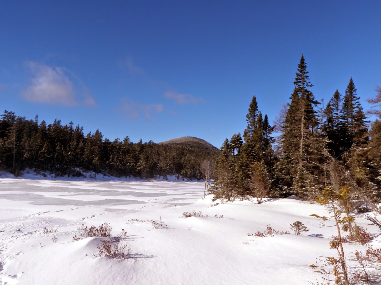
We parked at a pullout just before the gate for Cherry Mountain Road (northern side) and began the road walk to the summer trailhead for the Cherry Mountain Trail.


Heading up the Cherry Mountain Trail, which is used by snowmobiles in winter to reach the summit of Mount Martha.


We brought the snowshoes but never really had to use them as the Cherry Mountain Trail was packed down enough from the snowmobiles that went up to the summit throughout the day.


The trail junction for the Cherry Mountain Trail.  One part of the trail is for the eastern trailhead off of NH Route 115, which looked like it has seen very little activity recently.


The views of the Presidential Range that I have been denied twice before on prior hikes to the summit of Mount Martha.  It was cold where we were and we could just see the winds blowing snow around on Mount Washington so we could only imagine how cold it was there.


Looking north from the summit of Cherry Mountain (elevation 3573').


Cannon Mountain, Franconia Ridge, the Twin Mountain Range and the Bretton Woods ski area from a ledge just below the summit of Mount Martha.


The southern edge of the Presidential Range, Crawford Notch and Bretton Woods ski area from the ledge just below the summit of Mount Martha.


Coming off of the summit of Mount Martha through this snow tunnel.  You have to be careful hiking on this trail in winter due to the snowmobiles that go to the summit.  They obviously have right-of-way.


We decided not to head over to Owl's Head, even though the views are much better from there than they are on the summit of Mount Martha, mainly due to time and the length of the hike already (it's another 1 mile one way to the summit area for Owl's Head).   So we headed back down for the long 5+ mile hike back to Brian's car.  

View success from this summit!  While this is the long way to do Mount Martha it never felt too tough and although it was bitterly cold, I think we were spared the high winds we could have gotten on other higher peaks.

Sunday, January 25, 2015

Mount Nancy - Duck Pond Mountain: 1/25/2015

Mileage: 10.05 miles
Elevation gain: 3340 feet
Trails used: Nancy Pond Trail, Mount Nancy Trail (not maintained), bushwhack.
Highlight(s): 


It was roughly a year ago that we first tried to do Mount Nancy on a frigid day in January.  Fast forward to 2015 and it was almost the same kind of conditions outside; snow coming down, overcast and cold temperatures. The only difference is that the trail was in a lot better condition than last year and two people ahead of us, Jeremy and Bryan, managed to make the trail a bit more tolerable.

Mount Nancy and Duck Pond Mountain are located in Livermore, New Hampshire. Mount Nancy has an unmaintained trail that runs to its summit.  Duck Pond Mountain is a wooded, trail-less summit and requires a bushwhack to reach its high point.

Mount Nancy is on the New Hampshire One Hundred Highest List, New Hampshire Two Hundred Highest List, the New England 100 Highest List, and New Hampshire 3K List.  Duck Pond Mountain is on the New Hampshire Two Hundred Highest List and New Hampshire 3K List. 


We parked at the Nancy Pond Trailhead off of Route 302, where there was one other car there when we arrived.  It was snowing pretty good when we started heading up the Nancy Pond Trail.


Brian heading up a section of the Nancy Pond Trail that was relocated a bit higher up off of the old section of eroded, washed out trail.


Frozen over Nancy Cascades.  It seems like we have been here at least 10 times before.


The snow stopped a bit before Nancy Cascades and then the clouds started to part and the sun came out to play.  This is looking to the ridge coming off of Mount Bemis.


The views above the Nancy Cascade area looking to Stairs Mountain, Mount Resolution and Mount Crawford.


Mount Anderson starting to make its presence known as we start to cross Nancy Pond.


It's not every day you get to cross on a frozen pond.  The winds were high today which kicked up a lot of snow which is why there is drifting going on.


Brian entering the terrifying Pemigewasset Wilderness.


Its not often Brian gets to ponder the meaning of life sitting on a rock in the middle of frozen Norcross Pond.  Either that or he's wondering why we're doing this hike.


The always impressive views from the end of Norcross Pond looking towards the Bonds.  Cool looking cloud formations over Mount Bond.


Nice views from the summit of Mount Nancy looking east.  Mount Bemis is close by, Kearsarge North in the far right corner.  The long Montalban Ridge with Mount Crawford, Mount Resolution and Stairs Mountain.  Mount Parker is to the right of Mount Crawford.


Looking towards Big Attitash and the ski area, with the Langdon-Stanton-Pickering Ridge from the summit ledges on Mount Nancy.


Looking into the Crawford Notch area with the Presidentials in the clouds.


Me on the summit of Mount Nancy (elevation 3926').


A section of the Mount Nancy Trail and woods coming down off of Mount Nancy.  This trail, although relatively short, is very steep in spots and stays pretty steady until you reach the summit of Mount Nancy.


The views of Mount Anderson, Vose Spur and Mount Carrigain from the slide area off of the Mount Nancy Trail.


Another view from Norcross Pond over towards the Bonds.


Reversing directions and heading back across frozen Norcross Pond.  It was fun walking across the ice that was just about frozen solid.


My face was frozen like this for quite awhile from the cold.  


We made a last minute decision to bushwhack the short distance over to Duck Pond Mountain, which Bryan and Jeremy did as well.  


The summit canister on Duck Pond Mountain (elevation 3340').


It was hard (for me) to walk across these in snowshoes, probably because last time I tried it I fell in the water here.


We headed back down the Nancy Pond Trail and made good time hiking back down to the car.  The weather turned out better than expected, although it registered the temperature colder when we returned to the car than when we started.  We got some good views and got in a couple of tough winter peaks.  

I will say thank you to Jeremy and Bryan for breaking the trail to the top of Mount Nancy, as they have been up in this area several times in the recent months.  That's dedication.  I think it will be quite some time before Brian and I will be back in this area.  

Wednesday, January 21, 2015

Carr Mountain: 1/21/2015*

Mileage: 6.4 miles
Elevation gain: 2385 feet
Trails used: Three Ponds Trail, Carr Mountain Trail.
Highlight(s): 


I took Wednesday off from work to specifically hike one of my few winter four thousand foot peaks that I have left but once I woke up, it was hard to get any motivation to  do the drive, or even to do a hike today. I decided to pick something closer, and easy, to hike. The weather forecast for the day was for sun and temperatures in the mid twenties, so a bushwhack would be out of the question for today. 

Carr Mountain is located in Wentworth, Warren, Ellsworth and Rumney, New Hampshire. The actual summit (or summits, since there about three bumps of almost equal height) is in Wentworth, though the old fire tower summit is the recognized high point of the three. There are two different trails you can take to reach the summit; the Carr Mountain Trail from the NH25 side but I would be using the one from the Stinson Lake side off of Stinson Lake Road. There are views from the summit area of Carr Mountain.

Carr Mountain is on the New Hampshire Two Hundred Highest List and the New Hampshire 3K List.


I managed to make my way into the Three Ponds Trailhead parking area to start the hike. There was quite a bit of frozen snow so it was a bit slick.


The Three Ponds Trail is an active snowmobile trail in winter.  


After a brief short steep hike on the Three Ponds Trail, you turn left to head towards the summit of Carr Mountain on the Carr Mountain Trail.


The crossing of Sucker Brook was fun to do. I had to bushwhack a few feet down from the Carr Mountain Trail to make my way across a snow covered tree/snow bridge.


A few days old snowshoes track is all that remained after a few days of rain and cold temperatures. I was able to Microspike my way from bottom to the summit of Carr Mountain and back down.


You can barely see Mount Moosilaukee through the tree's here.  


The Carr Mountain Trail does make a few switchbacks as it steadily climbs up to the summit of Carr Mountain.


The snow laden tree's on the way up at about 3000 feet. The snowshoe track was blown-in in spots but still easy to follow.


Approaching the summit of Carr Mountain (elevation: 3453 feet) as the old fire tower footings come into view.


I stood on one of the fire tower footings on the summit of Carr Mountain and got this view of Mount Moosilauke, North Kinsman, South Kinsman, Cannon Mountain, Mount Clough and Jeffers Mountain.


Views of Franconia Ridge, with Mount Liberty, Mount Flume, and North - South Twin from the summit of Carr Mountain.


Views towards the Tripyramids, the Sleepers, Mount Passaconaway, Mount Whiteface and Sandwich Dome from the summit of Carr Mountain.


The Presidential Range and Mount Washington stood out nicely today from the summit of Carr Mountain.  


I reversed directions and headed back down to the car in less than an hour's time. 

A nice short day hike.  This peak is definitely a peakbagger's delight.  On a good day though, the views to the east and north are not that bad.  Otherwise, the draw is that the woods in the summer are nice and while the snow makes everything cool looking (in a different way), I would prefer to do this hike when its warmer out.  Next time Ill try this from the NH25 side.

Sunday, January 18, 2015

Mount Cube: 1/18/2015*

Mileage: 4.15 miles
Elevation gain: 1600 feet
Trails used: Cross Rivendell Trail.
Highlight(s): 


Kris and I had been planning this for awhile but due to the winter weather and its ever changing habits, we decided to do something quick and easy for Sunday.  A storm system was supposed to move in midday with freezing rain and snow, so Mount Cube fit the bill nicely.  Recently, Joe, Bob, Desi and Becky went up the Cross Rivendell Trail and I heard nothing but good things about it from Desi so instead of doing the boring Appalachian Trail section, we decided to give the trail a try.

Mount Cube is located in Orford, New Hampshire.  The Appalachian Trail runs over its summit as it continues north.  The summit of Mount Cube is the eastern summit of the Cross Rivendell Trail, a 36 mile trail that starts (or ends depending on how you do the trail) at Flagpole Hill in Vershire, Vermont.  You can get different views from the north and south summits of Mount Cube, so if you have the time and energy try to hit both.

Mount Cube is on the New Hampshire 200 Highest List.


We would take the Cross Rivendell Trail up to the summit of Mount Cube.  The trailhead is located off of Baker Road on the left.  Winter parking on the right and a short walk to the actual kiosk and start of the trail.


A very organized kiosk that is complete with maps.  We wouldn't be needing the tick information today though.


The Cross Rivendell Trail really feels like it gets too steep, which it doesn't sans the last few feet you climb up the ledges to the summit.


The trail climbs at moderate grades and has quite a few switchbacks.  The snow was hard packed today so we wore Microspikes the whole hike.


Eventually, you enter into this nice spruce grove and more switchbacks.


An open area view along the Cross Rivendell Trail looking over to Sunday Mountain.


Interesting rock formations towards the summit area.


The quartzite ledge climb just below the summit of Mount Cube.


The predicted storm system moving into the area around Smarts Mountain.


The Dartmouth Outing Club (DOC) sign on the summit of Mount Cube (elevation 2909').


Number 90 of the 201 for Kris as he looks west into Vermont from the ledges just below the summit of Mount Cube.


We skipped the north summit and headed back down to hopefully beat the weather before we got home.  Alas we managed to make it to exit 24 before the roads turned to ice and we crawled to exit 17 where my car was parked.

The Cross Rivendell Trail is a nice trail.  If you want a short route to a nice mountain with good views (on a nicer day), this is the hike for you.  It never felt too strenous and was easy to follow.  A nice day despite the weather.