Sunday, November 30, 2014

Copple Crown Mountain - Cotton Mountain: 11/30/2014

I had to work Saturday so our hiking day was set for Sunday. Once again, we were pretty unsure where or what to hike due to the snow that we got over the Thanksgiving holiday. As per our usual selection process, we perused the New Hampshire Gazeteer and decided on a few possibilities: Copple Crown Mountain, some of the Belknaps that I had left, some Ossipee peaks that we had yet to visit or do some more sections of the Sunapee-Ragged-Kearsarge-Greenway. It was going to be a cold day with very low chance for longer distance views so doing these hikes was going to be hit or miss.  

Copple Crown Mountain

Mileage: 5.95
Elevation gain: 1260 feet
Trails used: Copple Crown Mountain Trail.
Highlight(s): views from summit ledges.


We decided to do Copple Crown Mountain first which is roughly in the same area of the Moose Mountain Reservation, a hike we did in October on a nicer day obviously. With fresh snow down, we had no rough idea of the conditions we would be looking at for this hike but were pleasantly surprised that while there was snow it was not too deep to warrant any kind of traction, IE snowshoes or micro-spikes. 

Copple Crown Mountain is located in both Brookfield and New Durham, New Hampshire. It is also the highest point in Brookfield, and the western slope is the highest point in New Durham (which we did not do today because of the snow depths off trail).  There also used to be a ski area on Copple Crown but it closed down roughly forty years ago. There are views from several viewpoint areas on both summits.

Old Copple Crown Ski Area

Copple Crown Mountain


We parked the car off of Moose Mountain Road which has room for 3 to 4 cars. We noticed recent tracks that continued in to the parking area for the Ellis R. Hatch Wildlife Management Area, where two trucks were parked.


There is a kiosk about 0.4 miles down the road at the parking area with all kinds of information on the snowmobile routes in the area.


There was recent snowmobile traffic which made hiking easier on these old woods roads with about 5 to 6 inches of snow down for us to hike through.


Brian trudging along in the semi-broken out trail. From here the Copple Crown Mountain Trail was blazed in blue and had these Copple Crown signs pointing you in the right direction. It was still a bit confusing to figure out just where the Copple Crown Mount Trail went.


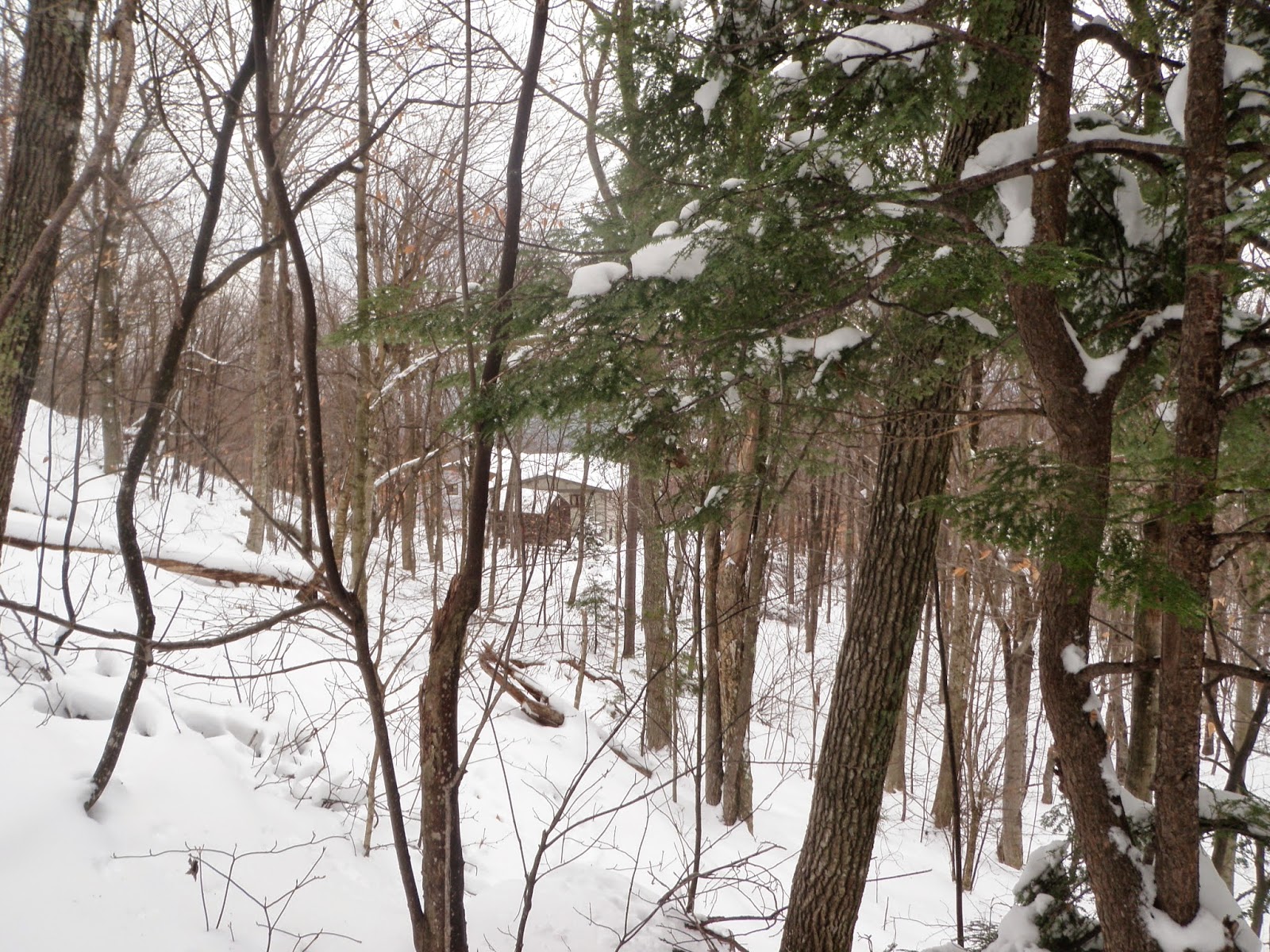
There were views of some houses of the private Copple Crown Community, which has a private trail. It would have been so much easier to do this hike if we could park down there as the Copple Crown Mountain Trail is about 200-300 feet from this house.


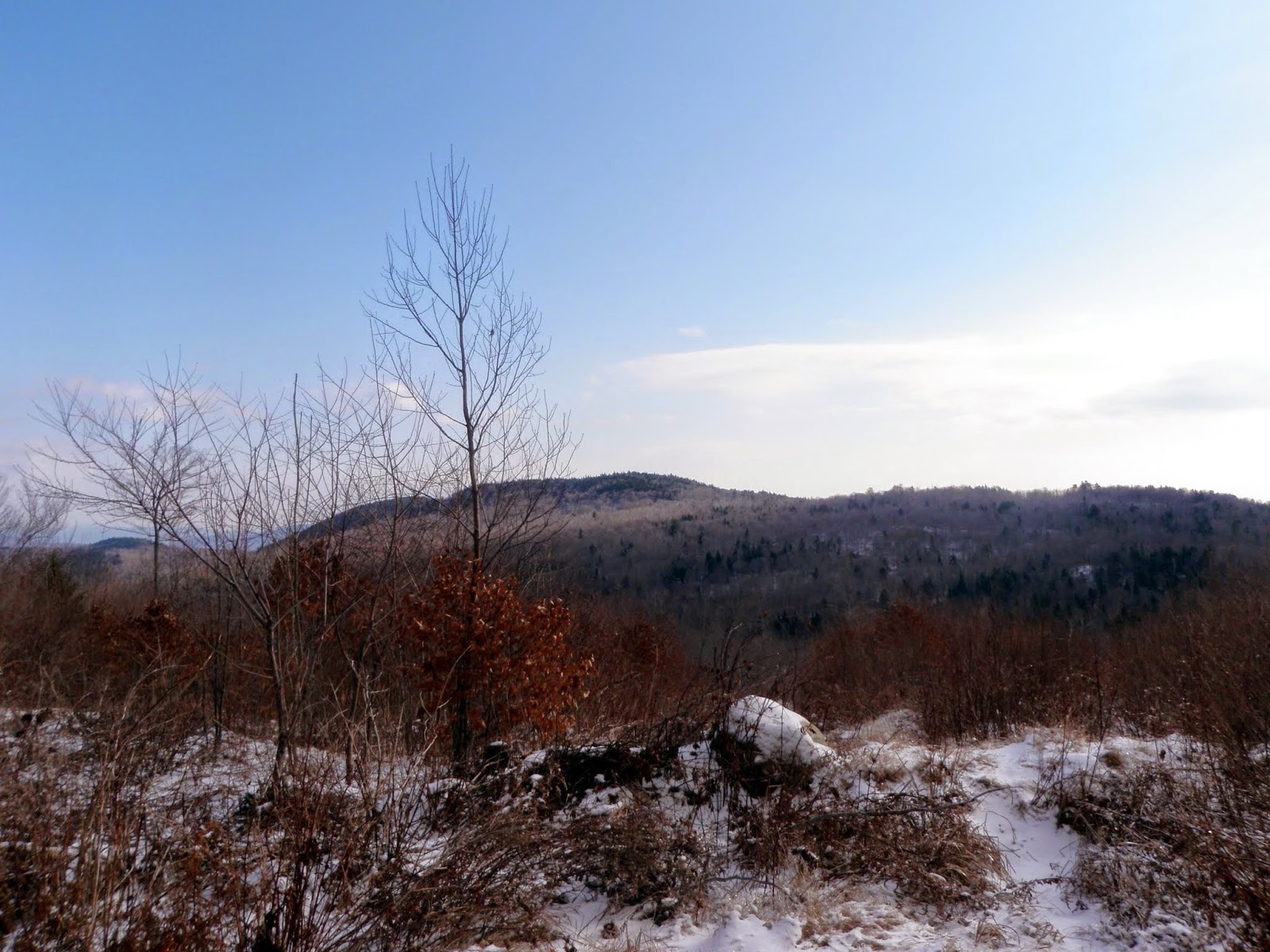
It definitely looks like winter up here. The Copple Crown Mountain Trail starts off as a gradual climb once off the woods road and gets a bit steeper towards the junction.


There is a junction where you get to choose between which summit, the main summit of Copple Crown Mountain or eastern summit, to visit. We would be doing both today.


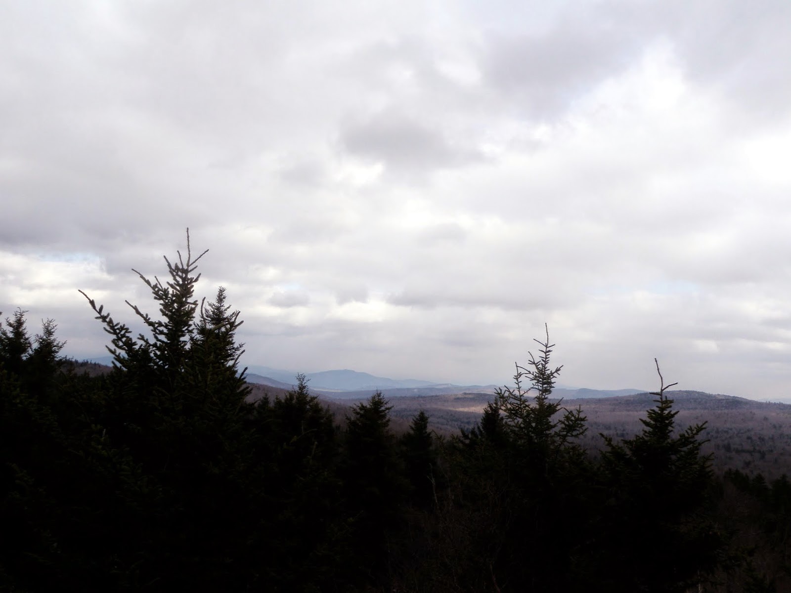
Due to the poor weather, this are the barely visible views of Belknap Mountain and Gunstock Mountain in the Belknaps from the eastern summit ledges of Copple Crown Mountain (elevation: 1820 feet).


Once back to the junction, we decided to break through the snow to the western summit of Copple Crown Mountain (elevation: 1868 feet), which seemed longer than the 0.3 miles post on the trail sign.


The views from the eastern summit ledges of Copple Crown Mountain looking over the nearby Moose Mountains, also in Brookfield.


At this point, we looked for something to hike on the way home as we were pretty sick of the snow. There were a few peaks in the Squam Range that we thought would be broken out so we headed that way.


Cotton Mountain

Mileage: 1.35
Elevation gain: 615 feet
Trails used: Cotton Mountain Trail.
Highlight(s): views from summit ledges.


We decided Cotton Mountain would be the last peak we would do on the way home since neither of us had been here before, and it possibly could have views despite the weather. It is a pretty popular area for hiking so we knew the chances of having a broken out trail were good.

Cotton Mountain is located in Holderness, New Hampshire and is part of the Squam Range at its southern terminus.  It is just around the corner from the Squam Lakes Natural Science Center. There are two summits to Cotton Mountain; the southern summit is crossed by the Crawford Ridgepole Trail and its northern summit is trail-less. There are views from the southern summit.


We parked at the Cotton Mountain Trail parking area off of NH 113, which was plowed out and had room for 3 to four cars.


The trails in this area are maintained by the Squam Lakes Association and protected by the Squam Lakes Conservation Society.


The Cotton Mountain Trail, which is actually an old road to a gravel pit area, at the start of the trail up to Cotton Mountain was a maze of trees bent over from the recent snowstorm.


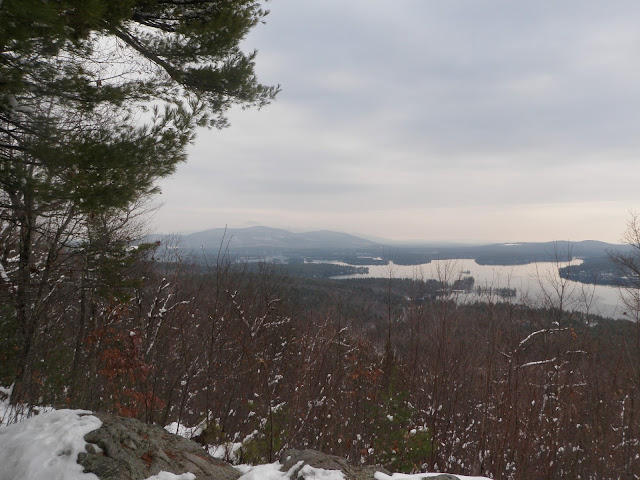
The views from the lower of the two summits of Cotton Mountain were better than Copple Crown Mountain at least. Here the view looks out over Squam Lake and towards Red Hill.


This is part of the Cotton Mountain Trail which runs through this nice tree area. The trail is blazed in yellow and is easy to follow.


A parting shot of the snow laden tree damage on the trail. We tried shaking the tree's to get snow off but it was pretty futile. We'll see what happens when it warms up.


These were two hikes with similar results: decent but not great views. Copple Crown Mountain is longer but obviously not as steep. Cotton Mountain was steep for its short length to reach its southern summit. Both could be nice family friendly hikes on nicer days and if you don't mind the views, these hikes are for you.  

Friday, November 21, 2014

The Rattlesnakes (Squam Lakes): 11/21/2014*

Mileage: 3.85
Elevation gain: 1110'
Trails used: Old Bridle Path, Ridge Trail.


Desi took Friday off so we decided to go for a hike.  We tossed around a few ideas to do (Belknap, Ossipees, Squam Range peaks) but decided to do West and East Rattlesnake Mountains.  We knew it was going to be a cold day so we made sure we were prepared and headed out.

The Rattlesnakes are located in Holderness, New Hampshire.  There are several hiking trails in this small area but the most popular one is the Old Bridle Path which starts off of Route 113 about 5 miles from Holderness/Route 3.  For more information and even a map of the trails for this hike, go here.


The start of the Old Bridle Path heading up.  It is very easy hiking up to the West summit of Rattlesnake Mountain from the parking area.


Some very nice trail work on a heavily used hiking area, especially in summer and on nice days. They ask for donations at the trail head to help with keeping the trails in good shape as well as keeping the parking area plowed in winter.


Please respect the land this hike is on.  We the heavy use it gets, it would be nice for future generations to have the ability to use and enjoy this area.


You can get some good views of the Squam Lake area on a good day, but today wasn't that day.


Looking west to the lower end of the Squam Mountains from the West Rattlesnake ledges.


More snow showers over Red Hill and Squam Lake from the West Rattlesnake ledges.  


We used the Ridge Trail to get over to East Rattlesnake.


The views towards Red Hill and the snow squall moving in, taken from some ledges just below the summit of East Rattlesnake which is the highest of the two summits.


Five Finger Point and looking to the Belknap Mountains


Desi heading back down on a snow/ice free section in between both summits.


The only serious ice section along the trail.  We did not use any sort of traction for this hike.


A cool looking rock on some lower ledges just down from the West Rattlesnake ledges.


The snow started letting up so we got this view of Mount Webster in the Squam Mountains.


Back to the car.  We passed one couple heading up as we were coming down but on a really nice day, this parking area is packed and cars down both sides of the road.


It was cold to start the day, and it was cold over the duration of the hike.  It spit snow for pretty much the whole hike as well.  Still, it was a nice hike and good to be out.  This hike also capped the end of my hiking week (since I took the whole week off from work) minus the big hike Brian and I would do on Saturday.

This hike is a family/kid friendly hike.  Please remember to leave a donation if you do this hike to help maintain this trail as well as keep the lot snow free for the winter.

Thursday, November 20, 2014

Catalouchee Mountain-North Peak * Mount Tug: 11/20/2014

Mileage: 8.0 miles
Elevation gain: 1735 feet
Trails used: none. road walk, bushwhack.
Highlight(s): views from the summit of Mount Tug.


Since I had the week off from work, this would be day two of hiking for me. I decided to head back up to the area to the west around Mount Cardigan (I hiked some peaks to the east of Cardigan the day before). There are plenty of peaks in this area to keep you busy for a good while. I have been in this area three time before so I was always curious what was further down New Colony Road (I have only ever been as far as the pond). I drove as far as I could on New Colony Road, where I parked off of the road and geared up.

Catalouchee Mountain-North Peak and Mount Tug are located in Orange, New Hampshire. Catalouchee Mountain-North Peak and Mount Tug are trail-less which means it requires a bushwhack and various old logging/woods roads to reach their respective summits. There are no views from the wooded summit of Catalouchee Mountain-North Peak. Mount Tug has nice views from its summit but *THIS IS PRIVATE PROPERTY SO PLEASE OBTAIN PERMISSION FIRST*.


I parked my car and started my hike by walking down the Orange Cove Trail, which is a continuation of New Colony Road.


The two summits of Catalouchee Mountain, which I had done twice before about two years ago.


Due to recent logging in the past few years, you can now get some nice views from the side of the logging road such as this one looking towards Mowglis Mountain.


Even more views north from the same logging area. You can see someone was actually brave enough to drive down this road.


After a roughly 1.8 mile road walk, I decided to head into the woods to begin my bushwhack up to the summit of Catalouchee Mountain-North Peak.


These woods were probably as thick as they would be for the entire hike on the way to the summit of Catalouchee Mountain-North Peak.  


The summit of North Catalouchee Mountain (elevation: 2338 feet) is very bumpy so it is tough figuring out which area is the high point.


I decided to head off the west side and down to Kimball Road, which is an old logging road that is also used by snowmobiles and other vehicles as evidenced by the recent tracks.


Please note, that before I begin this next section, this next hike was done without knowledge beforehand of any property/no trespassing issues.  Please do not attempt this hike unless you obtain permission first!!!


I bushwhacked straight up to the summit of Mount Tug (elevation: 2339 feet) through open woods from Kimball Road. There is a seasonal house up here which did not appear to be occupied at the time.


 There were decent views but I didn't stay long as it was very windy and cold.


There is even an observation tower on the summit which I did not attempt to climb, although the views from it are probably 360.


Views looking towards Carr Mountain with the Tenney Mountain wind turbines barely visible.


Mount Cardigan from the summit of Mount Tug, with Mount Kearsarge in the background.


A zoomed in picture of Mount Cardigan. You can barely see the fire tower on its summit.


Walking down a woods road with Mount Cardigan in the view.


There was some sort of foundation in the woods while I was walking back to the car along Number Seven Brook. Perhaps an old mill of some sort, or logging camp?


A tough 8 mile day of hiking, only because of the ice and measurable snow in the higher elevations and the fact that I did not bring any sort of traction for the conditions. While the first hike has no real redeemable qualities i.e views, it was a nice open woods walk. The second hike, if I had known about the property issues, I would not have visited this particular peak.  Please respect this private property and DO NOT ATTEMPT THIS unless you can somehow obtain permission first.

Sunday, November 16, 2014

Eagle Mountain (Jackson): 11/16/2014

Mileage: 1.8 miles
Elevation gain: 650 feet
Trails used: Eagle Mountain Path.
Highlight(s): slight views from several ledges below the summit of Eagle Mountain.


Desi and I wanted to go to the Settlers Green Outlets up in Conway, New Hampshire to get a jump start on our Christmas shopping so we decided to do a quick hike first. We knew it was going to be a cold day with somewhat obscured views due to the weather forecast calling for snow showers in the area. I remember reading the trail was somewhat difficult to follow but looking at the map, it seemed to follow the ridge to the summit so it shouldn't be too bad of a hike. We parked behind the Eagle Mountain House and started the hike.

Eagle Mountain is located in Jackson, New Hampshire. The path starts in the upper parking area of the Eagle Mountain House and is a pleasant woods walk with only one steeper section towards the summit area. The Eagle Mountain Path goes to the wooded summit of Eagle Mountain, although you can get views from several ledges on the way to the summit.


Desi starting out at the beginning of the Eagle Mountain Path. There is this small sign to guide you as you walk along an old woods road.


You turn right about 200 feet in and head up the ridge towards the summit. There are no blazes (that we could see) so it was a bit difficult to maintain a good pace without having to stop and see where the trail possibly went.


Its starting to get steeper as we climb towards the summit of Eagle Mountain. With the mixture of leaves still visible and snow on the ground, the footing was a bit rough.


The views from a ledge just below the summit of Eagle Mountain looking towards Thorn Mountain and Kearsarge North, behind it to the left.


The Attitash Ski Area getting swallowed by an approaching snow squall.


The summit of Eagle Mountain (elevation: 1613 feet). There is a bump to the north that could be debatable as far as being higher so we hit that one too as there was a red flagged trail heading in that direction.


We took our time going down the steep section and once down, it was a quick hike back out to the car and off for some shopping therapy.


Winter is well on its way, and its only a matter of time before the snowshoes have to come out of hibernation. While we didn't get any of the white stuff during this hike, it certainly was cold enough for it.

A nice little hike with semi views from some ledges around the summit. If you want a quick little hike with the kids, or after another hike in the area, this one fits the bill. Other than a little steep spot towards the summit, it was easy woods walking.