Mount Crawford
Mileage: 4.5 milesElevation gain: 2170 feet
Trails used: Davis Path, Crawford Spur Trail.
Highlights(s): Davis Path, 360 degree views from the summit area of Mount Crawford.
We have both down this hike previously in nicer conditions, so we figured the trail would be packed down so that we could use the Davis Path to reach the summit of Mount Crawford and possibly further. The hike up Davis Path to Crawford Mountain is always a popular hike and we figured it should be like a sidewalk up to the summit (even at this time of year), and we were not disappointed. We probably could have gone up without snowshoes but we decided to play it safe for the hike.
Mount Crawford is located in Hadleys Purchase, New Hampshire near Crawford Notch. The Davis Path is one of the oldest and longest routes to Mt Washington at about 15 miles in length. The summit and surrounding ledges of Mount Crawford offers 360 degree views.
Mount Crawford is on the New Hampshire Two Hundred Highest List, the New Hampshire 3K List and New Hampshire 52 With A View (52 WAV).
We hiked at the hiker parking area off of Route 302 and began the hike. You have to cross this suspension bridge, Bemis Bridge, to start the hike on the Davis Path.

The Bemis Bridge crosses over section of the Saco River, which is snowy and iced over at this time of late winter.

You come across this Davis Path sign board with a little history of the trail early on in the hike.

Almost immediately, you cross into the Presidential Range - Dry River Wilderness.

As we figured, the Davis Path was a packed down snow sidewalk. My snowshoes would go for a ride again, even though I was tempted to put them on several times.

If you look closely, you can see hundreds of snow fleas (dark blue springtails). On warm winter days, they come out to play.

The ledges heading up towards the summit area of Mount Crawford with views towards Mount Hope, Bear Mountain, Bartlett Haystack, Mount Tremont, and Mount Passaconaway.

The Davis Path passes by some ledges below the summit giving you a preview of the views to come on Mount Crawford of Mount Carrigain and Vose Spur, Mount Bemis and Mount Nancy and the tops of Mount Lowell and Mount Anderson.

The views of Mount Willey from the lower ledges as we are heading up to the summit area of Mount Crawford.

The views of the Attitash Mountain ski area and North Moat from the ledges heading up to the summit area of Mount Crawford.

Before too long we we were at the Davis Path and Mount Crawford Spur Trail. The Davis Path continues on from here towards Mount Resolution, Stairs Mountain and points north.


The short spur path up to the summit of Mount Crawford is a short but steep climb and there was just enough snow covering the usual icy spots.

The views from the summit of Mount Crawford of Mount Eisenhower, Mount Monroe and Mount Washington, which were almost in the clear today.

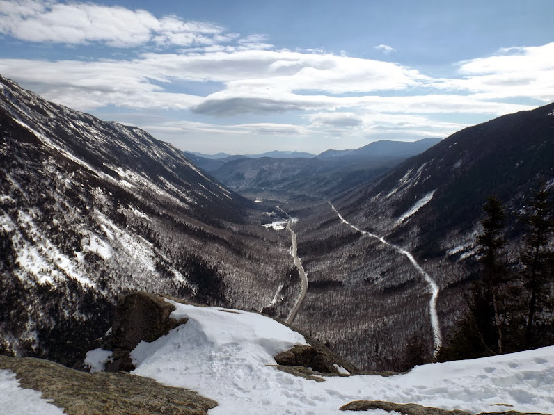
The views from the summit of Mount Crawford of Crawford Notch, Mount Willey, Mount Webster, Mount Jackson and the Frankenstein cliffs area.

A zoomed in view from the summit of Mount Crawford of Bear Mountain, with Mount Chocorua right behind it.

The views from the summit area of Mount Crawford of Mount Guyot, Mount Bond, Bondcliff, Mount Lincoln and Mount Lafayette.

The views from the summit area of Mount Crawford of Mount Carrigain, Mount Lowell, Mount Anderson, and Vose Spur.

The views from the summit area of Mount Crawford of Stairs Mountain and Mount Resolution. Mount Washington is to the far left.

The plan was to head over to Mt. Resolution, possibly even Stairs Mountain, just further up the trail. At the Crawford Spur sign, the Davis Path continues on and we noticed the trail not very well broken out, so with unpleasant memories of the previous weekends snowy un-tracked mess on Moose Mountain, we decided to give up the second part of the plan and go do something else in the area. We went back down to the car and decided to head back the way we drove into Crawford notch and do another great views hike.
Mount Willard
Mileage: 3.25 miles
Elevation gain: 1045 feet
Trails used: Mount Willard Trail.
Highlight(s): views from the summit ledges of Mount Willard.
Highlight(s): views from the summit ledges of Mount Willard.
We had both done this hike before but never in winter so we figured it would make for a quick hike up to the summit, where there would be good views. This is a popular hike in winter, as it is usually packed down by snowshoes and the Appalachian Mountain Club operates a lodge near here year round, where they lead hikes up to the cliffs around the summit of Mount Willard.
Mount Willard is located in Bethlehem, New Hampshire and in Crawford Notch State Park. The Mount Willard Trail goes to the ledges below the summit of Mount Willard where there are decent views looking into Crawford Notch and peaks in the area.
Mount Willard is on the New Hampshire 52 With A View (52 WAV).
This is the old Crawford Train Depot at the start of the Mount Willard Trail near the AMC Highland Center. Mount Willard is right behind it.


The Avalon Trail is used for only 100 yards before we turned on to the Mount Willard Trail.

Once again, we get a nice packed sidewalk for the Mount Willard Trail. The AMC regularly leads group hikes up to Mount Willard so it comes at no surprise.


Along the way is Centennial Pool, which is normally a nice flowing water spot, but today it is nothing but deep snow.

The Mount Willard Trail approaching the summit of Mount Willard. This section of the Mount Willard Trail used to be an old carriage road that took people to the ledges on the summit.

Once on the summit ledges of Mount Willard, you get stunning views south into the lower Crawford Notch area.
The views from the summit ledges of Mount Willard of Mount Webster and Mount Jackson.

Also out on practice maneuvers was the New Hampshire Air National Guard's Blackhawk helicopter. While it is always neat to see it flying over head, one has to wonder if its not practice and they are doing an actual rescue mission.

For the purist's out there, the actual high point for Mount Willard is not the ledge area but a short distance into the woods behind the ledges. After hitting the high point and enjoying the views from the ledges, we made a quick hike back to the car and looked for something else to do on the way home.
Flume Gorge
Mileage: 2.05 miles
Elevation gain: 675 feet
Trails used: none.
Highlight(s): Flume Gorge.
Highlight(s): Flume Gorge.
The Flume Gorge is a natural gorge that is a paid attraction (late spring/summer/fall) that allows people to walk through the gorge.
The views as we walk towards the Flume Gorge area with Mounts Flume and Mount Liberty in the background.

The Flume Covered Bridge, which is one of the oldest bridges in New Hampshire, along one of the various walkways leading into Flume Gorge.

One of several buildings in the area that are closed for the season.

A big section of Flume Brook that was frozen over.

A big section of ice that was fun watching people, without traction, trying to navigate through or around to get to the ice climbing area.

Some sections of the boardwalk and bridges remain in winter.

The ice was every where you looked, especially as we headed into the Flume Gorge.

This is as far as the boardwalk goes in winter, where ice climbers practice their trade. It was fun watching them climb up and rappel down.

We headed deeper and deeper along the walking paths and came across this frozen section of water or what I would like to think is where the Flume Brook comes in.

The day is done and we are tired. Brian is hiking back out.

After two big hikes it was a nice end to the day with a short walk into the gorge to see the ice climbers. The weather and temperatures were better than expected and we enjoyed every minute of it. The views from Mount Crawford and Mount Willard are always nice, and the Flume Gorge is a great family destination in summer, and neat to see in winter.
No comments:
Post a Comment