Elevation gain: 3725 feet
Trails used: Undermountain Trail, Appalachian Trail, Elbow Trail.
Highlight(s): Appalachian Trail, views from the summit areas of Bear Mountain, Mount Race, and Mount Everett as well as various areas along the Appalachian Trail, Sages Ravine.
Our hope for this hike was to drive far enough south to hopefully avoid the deeper snow that we have faced so far this year in New Hampshire. We decided to try our luck on the first section of the Appalachian Trail from Bear Mountain, Connecticut to Jug End Road in Massachusetts. We did not have much information on the conditions so we would only hope this would be a low level snow hike. Our friend Jim said he would help us with a car spot, saving the need for only one of us having to drive the long distance and various tolls.
Bear Mountain is located in Salisbury, Connecticut and is part of the Taconic Mountains and is the highest summit in Connecticut but not the highest point (Mount Frissell has that honor) in the state. Mount Race and Mount Everett are located in Mount Washington, Massachusetts and also a part of the southern Taconic Mountains. Both Mount Race and Mount Everett are located in the Mount Everett State Reservation. There are views from the summit area's of Bear Mountain, Mount Race and Mount Everett and along the Appalachian Trail.
Berkshire Natural Resource Council maps
Mount Washington State Forest Trail maps


At this point, we decided to call the hike. The snowshoe tracks we had followed for quite awhile were starting to get sparse and the going was much slower. It was approaching 3 pm and we still had a 2.5 hour drive home so we decided to take the 1.5 mile Elbow Trail down to Route 41 and then road walk back to Brian's car. Adding to all of this, Brian's knee was a little achy and my ankle was really sore and swollen for some reason so it was a good decision to cut this short.

It was definitely a bummer that we could not complete the full section we intended to do but the mountains will be there in the future. Overall, this is a nice area to hike in and we still managed to get our 14.5 mileage in for the day. The weather managed to cooperate for a better part of the day, but the deeper snow depths as we extended this hike made the going a little difficult.
A huge thanks goes to our friend Jim Roy for driving over from his home in Springfield to take us to the start of our hike. It allowed us to take just one car on the long drive south and was a big help.
Bear Mountain is located in Salisbury, Connecticut and is part of the Taconic Mountains and is the highest summit in Connecticut but not the highest point (Mount Frissell has that honor) in the state. Mount Race and Mount Everett are located in Mount Washington, Massachusetts and also a part of the southern Taconic Mountains. Both Mount Race and Mount Everett are located in the Mount Everett State Reservation. There are views from the summit area's of Bear Mountain, Mount Race and Mount Everett and along the Appalachian Trail.
Berkshire Natural Resource Council maps
Mount Washington State Forest Trail maps
The Undermountain Trail kiosk at the trailhead parking area. We would use this trail to get to the Appalachian Trail and then onward to Bear Mountain and points beyond.
Mountain Laurel lined the trails through a lot of the hike, including the beginning section of the Undermountain Trail.
The Undermountain Trail was a mixture of hard packed snow and some stretches where the snow was gone completely. It was also very comfortable at this point with spring-like warmth down low.
This is the Paradise Lane Trail and AT junction. There is a popular camping site nearby.
Early on in the hike, this is one of the few water crossing's for the days hike.
Brian and I at Riga Junction, where the Undermountain Trail comes in from Route 41 and junctions with the Appalachian Trail.
We started to get some views looking towards Gridley Mountain (left) and Mount Frissell (right) with Round Mountain just below Mount Frisell.
We noticed blueberry bushes on the approach to Bear Mountain's summit, but it will be awhile for there are any blueberries ripe for the picking.
The views looking north from the summit of Bear Mountain to our next destinations: Mount Race and Mount Everett with Sages Ravine in the middle.
The views looking towards the Twin Lakes region of Connecticut from the summit of Bear Mountain. Snow showers started moving towards us.

The "true" summit of Bear Mountain (elevation: 2352 feet). Dwarf pitch pines were present here, and on the summit areas of Mount Race and Mount Everett.
The remains of a pyramidal tower that was built on the summit area of Bear Mountain. Several restoration attempts were undertaken until finally it was left as it currently is shown.
While following the Appalachian Trail off of Bear Mountain towards Mount Race, it got steep and icy in spots, but the woods were open like this most of the way.
Brian posing just before we are about to enter Sages Ravine. The trail itself was easy to follow and there are several waterfalls and is very popular with families and hikers alike. This would be nice area to take a dip in the water in the summer.
The snow has blown over a prior snowshoe track as we hike along the Appalachian Trail in Sages Ravine.
The popular Sages Ravine campsite is on the other side of the water. The Appalachian Trail crosses the wooden bog bridge.
Some images of Sages Ravine, which would look rather impressive in summer and with a good flow of water with all the waterfalls and chutes for the water to cascade down. We encountered a good deal of snow here.


We continue along the Appalachian Trail as we enter into Massachusetts.

Pretty much as soon as we passed the above sign, the skies opened up on us with wintery conditions (snow and sleet). So we put on the rain gear and continued onward along the Appalachian Trail and into Massachusetts.
As we come out the other side of Sages Ravine, the snow was almost non-existent, which is nice for early spring conditions.
The skies cleared and we came upon this structure. A molasses processing plant of some sort, perhaps. It looked lonely with its rake propped on the side. This was actually the privy for the Laurel Ridge campsite.
A re-vegetation area on Laurel Ridge around the Laurel Ridge campsite.
The views as we are coming out onto the eastern ridge line heading way up to Mount Race looking into southern Massachusetts and northern Connecticut.
I am looking down the cliff face along the eastern ridge line. It is roughly 700 feet down in about .25 miles so it would be a quick way down if you fell.
More open views along the eastern ridge line. Personally, i think this was one of the nicest stretches on this hike mainly for the open ridge walk and the views.
The views looking back towards where we started on Bear Mountain with Mount Round, Mount Frissell, and Mount Ashley on the right.
There was more dwarf pitch pine along the Appalachian Trail and on the way to summit of Mount Race. There are even scrub oaks along here too.
The summit high point of Mount Race (elevation: 2372 feet), which is just slightly off of the Appalachian Trail.
Brian looking over to Mount Everett in the distance, which is our next destination. It looks so far away from here. It was a bit steep and very icy going down off of the summit.
At the junction for the Race Brook Falls Trail and Appalachian Trail, which is about halfway between Mount Race and Mount Everett.
Brian is approaching the summit of Mount Everett, as the clouds start to move in.
Brian on the summit of Mount Everett (elevation: 2602 feet), or Bald Mountain as it is still named on some maps. These cement footings are for the fire tower that was on the summit
There are 360 views off the summit of Mount Everett. These views are looking towards Bear Mountain and Mount Frissell.
We could even faintly see the Catskills poking through the clouds in the distance, as rain/snow showers started moving in around us.
The Appalachian Trail sign at the Guilder Pond parking area, which is reached via the Mount Everett Auto Road.
We are continuing our hike as we head towards the Appalachian Trail/Elbow Trail junction. We still had a few more miles to hike to reach the car we left at Jug's End so we had to make a quick decision on what to do next.
At this point, we decided to call the hike. The snowshoe tracks we had followed for quite awhile were starting to get sparse and the going was much slower. It was approaching 3 pm and we still had a 2.5 hour drive home so we decided to take the 1.5 mile Elbow Trail down to Route 41 and then road walk back to Brian's car. Adding to all of this, Brian's knee was a little achy and my ankle was really sore and swollen for some reason so it was a good decision to cut this short.
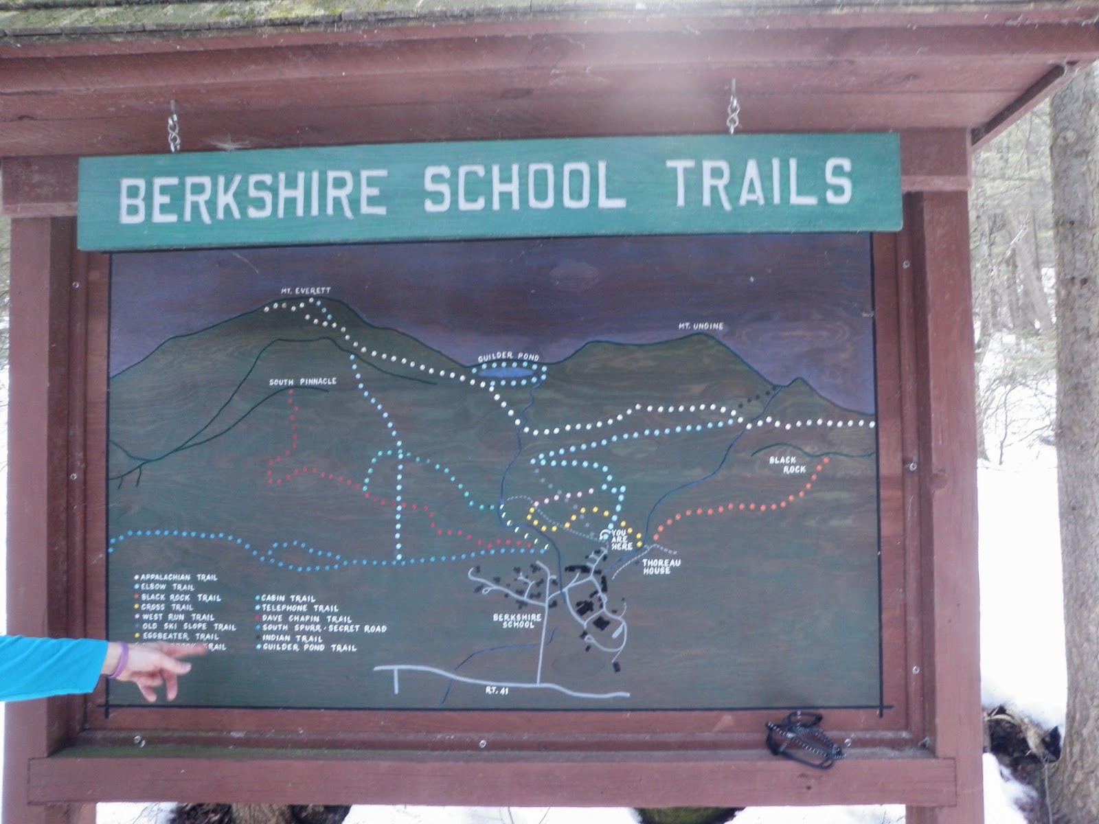
The Berkshire School maintains a good deal of hiking /ski trails in the area. This is the Elbow Trail kiosk, which has a map of them.
The color coordinated matching trails for the above picture.

It was definitely a bummer that we could not complete the full section we intended to do but the mountains will be there in the future. Overall, this is a nice area to hike in and we still managed to get our 14.5 mileage in for the day. The weather managed to cooperate for a better part of the day, but the deeper snow depths as we extended this hike made the going a little difficult.
A huge thanks goes to our friend Jim Roy for driving over from his home in Springfield to take us to the start of our hike. It allowed us to take just one car on the long drive south and was a big help.
No comments:
Post a Comment