Saddle Ball Mountain
Mileage: 2.75
Elevation gain: 1355 feet
Trails used: Jones Nose Trail, Appalachian Trail.
Highlight(s): walk through old blueberry field, birding opportunities, Appalachian Trail, views from lower end of Jones Nose Trail, ledges along Jones Nose Trail.
I was going to do this hike last year but start on a different trail to reach the summit of Saddle Ball Mountain so I am glad I waited to do this one until now. I read the first part of this hike was through old blueberry patches and it is the perfect bird viewing area so it made it a bonus for the hike, especially for Desi since she likes to figure out what birds are what and which ones make certain calls.
Saddle Ball Mountain is located in New Ashford, Massachusetts and in the Mount Greylock State Reservation. It is the second highest peak in Massachusetts, behind only Mount Greylock. The Appalachian Trail runs over the summit of Saddle Ball Mountain on its way north/south along the eastern coast. There are no views from this wooded summit, but there are several view points along the way.
Mount Greylock State Reservation
Mount Greylock area map
The Jones Nose Trailhead parking area kiosk. Compared to some of the other parking areas in the Mount Greylock State Reservation this one was spacious.

The Jones Nose Trail is easy to follow and well signed at most junctions, including at the trailhead as we begin the hike.

The southern ridge of Saddle Ball Mountain known as Jones Nose as we start passing through a blueberry field. It is a nice place to sit and watch the birds that fly about the area.


The nearby closed Brodie Mountain Ski Area and it's current resident, the Berkshire Wind Power Project and its ten turbines.

As you climb along the Jones Nose Trail, you eventually enter into the trees as you continue your way along to the junction with the Appalachian Trail.

A few ledge areas as you head along the Jones Nose Trail, as it levels off before you reach the ridge where the trail junctions with the Appalachian Trail.

Another view of the Brodie Mountain area from some ledges along the Jones Nose Trail, which other than the views heading up from the parking areas are pretty much the only views to be had on this section of the hike.

Hiking along the Appalachian Trail and almost to the summit area of Saddle Ball Mountain.

The high point area for Saddle Ball Mountain (elevation: 3248 feet), which is the second highest peak in Massachusetts after Mount Greylock.

The junction of the Jones Nose Trail and Appalachian Trail. We opted for the out and back along the Jones Nose Trail.

Desi heading back down the Jones Nose Trail. Most of the Jones Nose Trail and Appalachian Trail was wet and muddy in the trees.

The junction of the Jones Nose Trail and CCC Dynamite Trail, which runs north to a parking area off of Rockwell Road.

Walking along the blue blazed Jones Nose Trail as it approaches one of its switchbacks.

Descending the Jones Nose Trail while we are heading back to the car with Rounds Rock looming in front of us.

Views of nearby Cole Mountain from the Jones Nose Trail.

It was a pretty uneventful hike back down to the car. We did pass three AT thru hikers and a few other groups with dogs but not many people while we were hiking the Jones Nose Trail section. Another hike was right around the corner so we hopped back in the car for the roughly half mile drive to the trailhead.
Rounds Rock
Mileage: 1.15
Elevation gain: 225 feet
Trails used: Rounds Rock Trail.
Highlight(s): low elevation gain loop trail, blueberries (in season), several view points, plane wreckage and memorial site.
We figured this next hike looked decent on the map, with little elevation gain and we were pleasantly surprised. It was nice that it was close to where we parked for the Jones Nose Trail, so it wasn't that long of a drive to get to the trailhead. Plus, the total round trip mileage was roughly about a mile, but it could be extended depending on the different trails you can take in the area.
Rounds Rock is located in New Ashford and Chesire, Massachusetts and also in the Mount Greylock State Reservation. There are no views from this wooded summit, but there are several viewpoints along the way with decent views south and west. Also, in season, there are good amounts of blueberry bushes around the summit area of Rounds Rock.
Mount Greylock State Reservation suggested hikes
This is the actual start of the Rounds Rock Trail. There is a parking area just off of Rockwell Road where you can park to access the Rounds Rock Trail.

We decided to go left and make the hike around the Rounds Rock Loop, hitting the high point first and then on to the two ledge areas and the blueberries.

Desi working her way up the trail, which was easy to follow. There isn't much elevation gain for this one so it was a nice walk in the woods.

The high point of Rounds Rock (elevation: 2559 feet). It even has a benchmark on the summit, but there are no views from here.

This interesting stone monument that I am not sure why it was here. It did have the date 1912 on it and the initials NA.

The views looking into southwestern Massachusetts from a view ledge on Rounds Rock.

Coming off the summit, this whole area was a big blueberry field. Some of the blueberries were ripe so we spent a few minutes picking some for Desi.

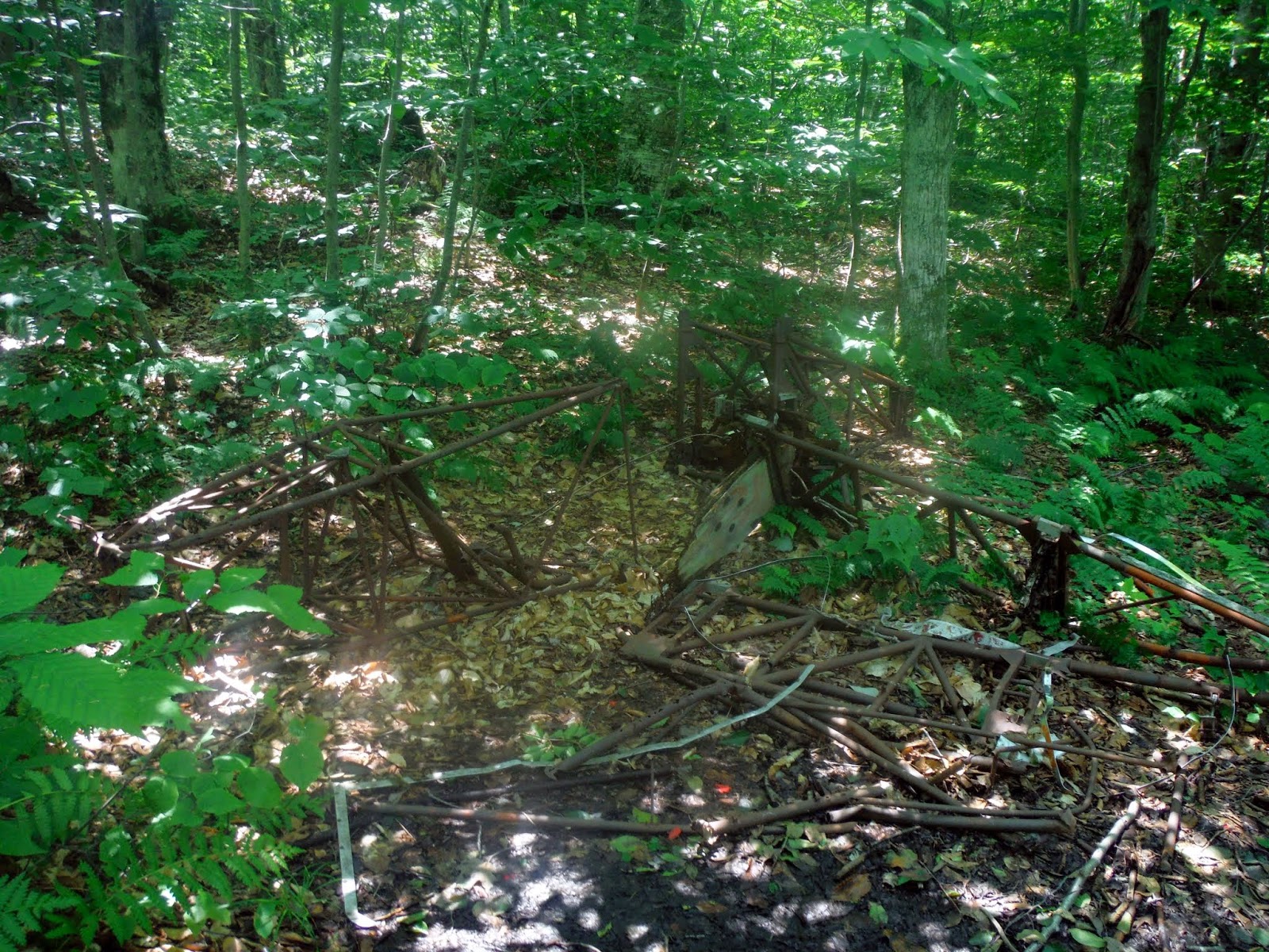
Along part of the Rounds Rock Loop, there is this memorial information on the pilot that crashed his twin engine Cessna here in 1948.

The only visible wreckage you can see of the Cessna that crashed here in 1948.
Not sure if this was some sort of memorial or an actual grave site but it was right around where the plane crash wreckage was.

We figured we could possible have time for one more hike, so I suggested Stony Ledge. I figured since there was a campground there, and picnic area on the actual ledges we could drive a good distance in. I was wrong; the gate was closed so we had to make the trek on foot, but I figured we could make good time since it was walking on a dirt road with little elevation gain.
Stony Ledge
Mileage: 3.30
Elevation gain: 500 feet
Trails used: None. Sperry Road.
Highlight(s): Sperry Campground, views from summit ledges.
We had to park at the CCC Dynamite Trailhead parking area, then cross the road to start the road walk down Sperry Road to get to the Stony Ledge and its picnic areas and views. If the gate into the Sperry Campground was open we could have driven to the summit but it wasn't, hence the road walk. There were quite a few people camping in here too, so it is quite a walk to get to the many camp sites.
Stony Ledge is located in Williamstown, Massachusetts and in the Mount Greylock State Reservation. The Sperry Campground is located here as well, as you need to hike/bike in on Sperry Road to reach the view point area for Stony Ledge. There are also several picnic benches on the summit so you could hike/bike in and enjoy the views and lunch.
Mount Greylock State Reservation campground information
On the other side of the gate on Sperry Road that heads down towards the Sperry Campground and Stony Ledge picnic area.

Water was flowing pretty nicely from the various streams and cascades in the area.

Sperry Road was a long 1.6 miles from the gate to Stony Ledge. You walk through the Sperry Campground and pass various other trails.

The high point of Stony Ledge (elevation: 2579 feet) actually has a picnic bench on it.

A view point ledge (complete with picnic tables) with views looking towards the summit of Mount Greylock, where its summit buildings were barely visible.

Views of Mount Prospect, Mount Williams and Mount Fitch from the ledge area on Stony Ledge. We could see into Vermont and were able to get good views of the Hopper down below us. The Hopper is a glacial cirque that resides on the western side of Mount Greylock.

A wonderful day for these three hikes with the only downer being the long drive from our house in New Hampshire, to the Mount Greylock area, and back. The fields along the Jones Nose Trail offer birding oppurtunites galore, a somber hike on Rounds Rock to an old plane crash, and unique views of The Hopper cirque in between Mount Greylock and Stony Ledge made this an enjoyable day, with no precipitation and low temperatures.
I'm guessing the monument on Round Rock indicates the New Ashford town line.
ReplyDeleteGood deal, Ken. I figured it was either that or North Adams, and possibly some sort of boundary line.
ReplyDelete