Red Hill South Peak
Mileage: 5.15
Elevation gain: 1455 feet
Trails used: Sheridan Woods Trail, bushwhack.
Highlight(s): old woods road/trail.
Highlight(s): old woods road/trail.
I saw a post on this hike last year but decided I would try it while the trail was dry (it was a snowshoe trip report) so once I found out exactly where the trail started, I made the drive through Meredith, New Hampshire and into the Lakes Region of New Hampshire. Brian and I did Red Hill last year, which has a fire tower on its summit. This is the lower summit found to the southwest.
Red Hill South Peak is located in Moultonborough, New Hampshire. The less-visited Sheridan Woods Trail is a mixture of hiking trail, old woods road and snowmobile trail. I believe there is even some XC ski trails in the area. There are slight views from one of the two summits of Red Hill South Peak but I would imagine they are better in the winter.
The Sheridan Woods Trailhead kiosk off of Sheridan Road. There is plenty of parking here for probably about 5-10 cars.

Blurry view of the start of the Sheridan Woods Trial which is a snowmobile trail in sections of the hiking trail.

There is an obvious track and some sort of markers along the Sheridan Woods Trail. I came upon several different junctions so I pretty much kept going right.

The overgrown Garland Pond Overlook, with a sign of the mountains that were supposed to be seen from here but just barely.

The junction for the Garland Pond Overlook, complete with bench. It is a short 0.2 mile hike to get to the overlook.

The Sheridan Woods Trail gets even more grown in as you get near the summit of Red Hill South Peak.

I followed a snowmobile trail that started heading for the summit of Red Hill South Peak, but had to start bushwhacking as it headed back to the north.

One of a few high points of Red Hill South Peak (elevation: 1780 feet). There are no views from this wooded summit.

Pretty much the only good views from a lower summit of Red Hill South Peak, which the actual Sheridan Woods Trail goes to. This is looking towards Mount Israel with Sandwich Dome just behind it in the background.

Hiking back out along the Sheridan Woods Trail. It was getting a bit warm outside but I needed to keep the long sleeves on because of the mosquitoes.

I found that I forgot to turn my tracks on when I was on the main summit of Red Hill South Peak so I only had half my tracks for the trip, but other than the minor summit, I just added another 2 miles to the total. My next hike would take me a ways into Tamworth, and would be a bushwhack with tough access.
I really need to get a better camera. The pictures always manage to come out blurry if there's not enough light.
Grant Peak/Nickerson Mountain
Mileage: 4.1
Elevation gain: 1465 feet
Trails used: roadwalk, logging cut, bushwhack.
Highlight(s): logging cut bushwhack, views from old ski area.
Highlight(s): logging cut bushwhack, views from old ski area.
This is a peak we tried last year but could not hike up the ATV access road due to No Trespassing signs at the start of the gated road. So, while this would make doing this peak an easier affair, I would have to resort to doing this one of several ways: hiking up the overgrown old ski slope or lift line to the summit or bushwhacking from several different points around Nickerson Mountain.
Nickerson Mountain, or Mount Whittier as it was once known, is located in Ossipee, New Hampshire and is considered a part of the Ossipee Mountain range in eastern New Hampshire. Mount Whittier is currently labeled as the peak directly to the west of Nickerson Mountain, and is also a bushwhack.
Nickerson Mountain was home to the now defunct Mount Whittier Ski Area. There is currently a communications array on the lower summit of Nickerson Mountain so access is limited. For more information on the ski area history, go here.
I parked at the gate on Gilman Valley Road and walked about 0.3 miles down to this old logging landing and used various old logging cuts to get near the summit of Grant Peak.

One of the few old logging roads I would use to get to the summit of Grant Peak. It was right around here that I spooked a good sized male deer.

The woods were nice and open once I was off the logging roads and beginning the bushwhack portion of the hike up to the summit of Grant Peak.

I came across this rock slide on the southwest side of Nickerson Mountain. It was pretty hot here as the heat radiated off of the rocks as I climbed up slowly.

Just below the summit of Grant Peak, I got this view towards Mount Shaw in the nearby Ossipee Range.

One of Ed's black canisters which was not on the summit of Grant Peak, but at a slightly lower elevation and lower contour. I signed in anyways to let whoever follows me that this is the wrong spot. There was only one person who had written in it from December 2014.

The high point of Grant Peak (elevation: 1783 feet), which is wooded.

I made my way over towards the old Mount Whittier Ski Area peak through nice woods.

Looking down the old defunct gondola lift line and towards Kearsarge North from the summit area of Nickerson Mountain.

An old junker fuel or water truck around the old Mount Whittier Ski Area

The Mount Whittier Ski Area summit gondola building which is a bit rundown. I didn't go inside as the floor didn't look very sturdy.

There is currently a communications tower right next to where the old ski area is, and an ATV access path that comes up from Gilman Valley Road.

Views over towards Sandwich Mountain and the Sandwich Range as I walked a little of the ATV trail as I headed back to the car.

I didn't want to hike down the ATV trail as I wasn't sure it was trespassing or not so I hopped into the woods here but not before getting this picture of Bald Mountain and Mount Whittier.

I made decent time back down to the car after a short road walk and then decided I would start heading back towards home and see if I could find something along the way to do as a final hike. I almost decided not to do anything else but I remembered another peak I tried to do last year so I decided to give it a go.
Burleigh Mountain
Mileage: 1.50
Elevation gain: 575 feet
Trails used: road walk, Burleigh Mountain Trail, bushwhack.
Highlight(s): moderately steep trail to summit area, views from old ski slopes.
Highlight(s): moderately steep trail to summit area, views from old ski slopes.
I attempted this peak last year but I wasn't sure about access to reach it. Once I did a little digging online, I managed to find out that you can hike on the property but you should not drive in. There was adequate parking outside the Private Drive sign and it wasn't a long walk to reach the trailhead.
Burleigh Mountain is located in New Hampton, New Hampshire. The New Hampton School operated a ski area for the school until the early 1980's. Some information on the history of the ski are can be found here.
Walking along Burleigh Mountain Road which leads to the Burleigh Mountain Trail.

The Burleigh Mountain Trail goes up to the left side of this old ski slope that is quite grown in now and was the home of a rather pissed off grouse and his ilk.

The Burleigh Mountain Trail got a little narrow as I reached the top of the ski area before it heads into the woods.

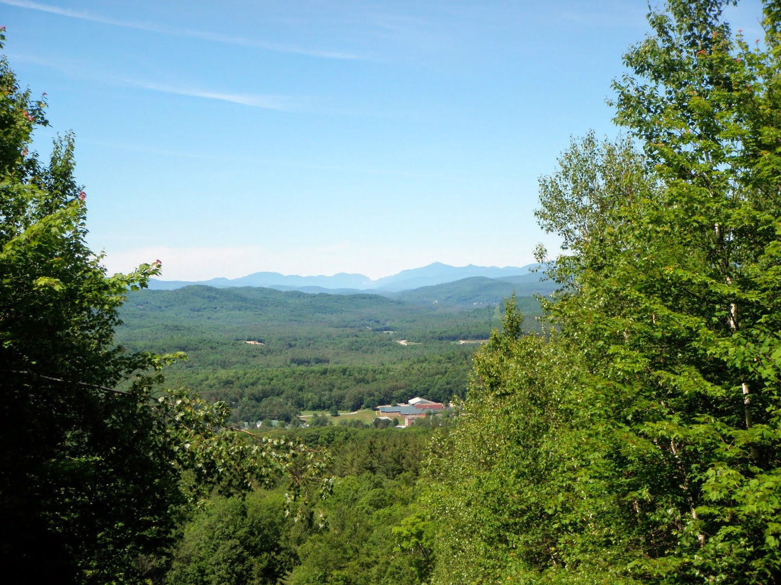
Looking northwest from the ski slopes on Burleigh Mountain towards Bristol Peak (left) and then Carr Mountain, Plymouth Mountain and Mount Moosilaukee.

Views of the Kinsmans, Cannon Mountain and Franconia Ridge from the ski trail heading up to the summit of Burleigh Mountain.
I ended up bushwhacking to the summit of Burleigh Mountain (elevation: 1462 feet) as I lost the Burleigh Mountain Trail shortly after it entered the woods.

A (incorrect elevation) summit sign for Burleigh Mountain as I found the Burleigh Mountain Trail as I headed down.

Back down at the bottom of the Burleigh Mountain Trail is this adventure course area for the New Hampton School.

A nice three hike day. The last hike up Burleigh Mountain was pretty hot and I went without my backpack as I figured it would be quick so I paid by not having water with me. Other than, decent views from the old Mount Whittier Ski Area and from Burleigh Mountain so overall a good day.
No comments:
Post a Comment