We had a rough plan in place, with quite a few short and low elevation trips on the docket. I asked that we take two cars just in case I ran out of steam; I did not want to hold Brian back from getting more done if I managed to not hold out the entire time. So we met at the usual meeting place, and made the drive up north to Lincoln, New Hampshire.
Discovery Trail Interpretive Site
Mileage: 1.45 miles
Elevation gain: 385 feet
Trails used: Forest Discovery Trail Loop.
Trails used: Forest Discovery Trail Loop.
Highlight(s): interpretive signs with history of the area.
Type of Hike: Trailed.
Views: No
Our first stop, and first hike, would be along the Kancamagus Highway and a place we had passed by numerous times on the way to other hikes. Today would be the day to get some red-lining done and what a perfect warm up hike. It is a good hike for parents with young children and the path is well maintained and easy to follow. I do think there needs to be more of these kinds of hikes along the Kanacamagus Highway as it is a big tourist area, and lots of families do travel and camp around here.
The Forest Discovery Interpretive site, located in Lincoln, New Hampshire, has interpretive panels along the trail that one can stop and read the history of forest management in the area in the past and present.
We geared up fairly quickly and headed out early to begin the days fun. The temperatures were comfortable, which is weird for a summer day in mid July.


After an easy ramble through the woods, we were back at the cars before we knew it. Hike two was a little bit of a drive up and over Kancamagus Pass, and just before Bear Notch Road. We had decided we would try and red-line most of the short trails along the Kancamagus that we have never been to. The weather to this point was perfect: just comfortable enough with a breeze and partly cloudy. No bugs to be seen, either.
Our first stop, and first hike, would be along the Kancamagus Highway and a place we had passed by numerous times on the way to other hikes. Today would be the day to get some red-lining done and what a perfect warm up hike. It is a good hike for parents with young children and the path is well maintained and easy to follow. I do think there needs to be more of these kinds of hikes along the Kanacamagus Highway as it is a big tourist area, and lots of families do travel and camp around here.
The Forest Discovery Interpretive site, located in Lincoln, New Hampshire, has interpretive panels along the trail that one can stop and read the history of forest management in the area in the past and present.
We geared up fairly quickly and headed out early to begin the days fun. The temperatures were comfortable, which is weird for a summer day in mid July.
Brian inspecting the trailhead kiosk and map for the Forest Discovery Trail.

The Forest Discovery Trail is a loop of about 1.5 miles with easy grades and wheelchair accessible walking trails.

A section of the Forest Discovery Trail. This hike has interpretive panels alongside the trail to describe the history of the land/area.

The web of life: forest ecosystems.

The forest: where change is the only constant.

One, two...tree by tree.

Fields in the forest: wildlife openings.

The sheltering woods.

Patches of sunlight spark new growth.

The only real views (not a very good picture) we got along this hike

A fresh start.

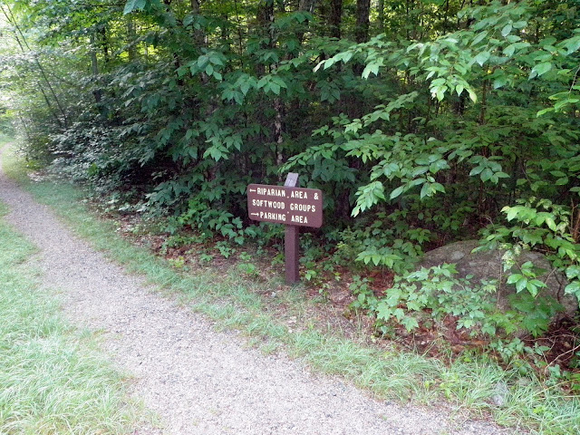
We went left and took the loop trail towards the Riparian and softwood section, and then would head back to complete the first hike of the day.

Streambanks and salamanders: the riparian zone.

The only water crossing of the hike goes over a small brook.

Openings in the forest.

Forest roads: where do they lead?

The old timers: mature hardwood forests.

After an easy ramble through the woods, we were back at the cars before we knew it. Hike two was a little bit of a drive up and over Kancamagus Pass, and just before Bear Notch Road. We had decided we would try and red-line most of the short trails along the Kancamagus that we have never been to. The weather to this point was perfect: just comfortable enough with a breeze and partly cloudy. No bugs to be seen, either.
Church Pond Loop Trail
Mileage: 2.75 miles
Elevation gain: 505 feet
Trails used: Church Pond Loop Trail.
Highlight(s): Church Pond.
Type of Hike: Trailed.
Views: Yes
This is also another hike we have driven by quite a few times but had never done. Today would be the perfect day to get it done, as it makes almost a nice little flat loop to and around a pond. We, at the time of the hike, were unaware that the eastern part of the Church Pond Loop Trail was closed several years ago as we had an older edition White Mountain Guide and map. That would explain the swamp/bog and overgrown trail we encountered on the northern and eastern side of the loop trail. Our clothes and shoes/socks after this hike bore witness to how horrible it was as we were soaked to the bone from the waist down.
The Church Pond Loop Trail, or Church Pond Trail as it is known now, is located in Livermore and Albany, New Hampshire. The only difficult part of this hike wasn't even that difficult: doing the crossing of the Swift River from the trailhead parking area and the other side of the Swift River, where the Church Pond Trail continues on to Church Pond.
The Nanamocomuch X-C Ski Trail intersects this area so make sure to check the signs at each trail junction.
We entered the Passaconaway Campground to get to the Church Pond Trail, and parked both cars at the trailhead (very limited parking, and closed in winter).

Brian giving the thumbs up as we had to take off our shoes and cross the moderately cold Swift River to get to the other side of the Church Pond Loop Trail.

At the junction for the Church Pond Trail and Nanamocomuck (X-C) Ski Trail.

There were numerous bog bridges in fairly good condition as we approached Church Pond, but not so true on the east side of the Church Pond Loop Trail.

As we walked along the Church Pond Loop Trail, we got glimpses of nearby Greens Cliff.

The views across Church Pond looking towards Sugar Hill, Scaur Peak, North Tripyramid and the Fool Killer.

We had an old trail map and trail description so we were unaware (until after talking to Steve Smith) that the east side of the Church Pond Loop Trail had been closed several years ago. Hence, why this section was overgrown and almost hard to follow.

Eventually we made it through the swamp areas, the overgrown trails that were wet from the rain the prior night and numerous blowdowns to this section. We made haste for the cars.

The water crossing of the Swift River, where we first crossed to start the hike. Since it was nice out, we decide to sit here and dry out before we crossed.

We had to cross the Swift River again, but it was refreshing after we relaxed in the sun to dry our clothes off and we didn't have to worry about hiking very far as the cars were just a stones throw away. Our shoes and socks were soaked from this hike, but luckily I had plenty of spare socks and shoes to make it through the day.
We drove out of the Passaconaway Campground and made the short drive down the road for our third hike of the day, which would end up being the shortest hike of the day. It gave us a few seconds of time to air out our wet feet though, as we drove down to the Passaconaway Historic site parking area.
Rail 'N River Trail
Mileage: 0.65 miles
Elevation gain: 160 feet
Trails used: Rail 'N River Trail.
Highlight(s): Russell-Colbath House, Passaconaway Historic Site.
Type of Hike: Trailed.
Views: No
This is also another one of those hikes that you pass along the Kancamagus Highway but probably never get out of your car to do. I think most people I see in the area are at the Russell-Colbath House (which is usually open this time of year) and Passaconaway Historic Site, where there is a good sized parking area.
The Passaconaway Historic Site and Russell-Colbath House are located in Albany, New Hampshire. There is a map at the Rail 'N River Trailhead, and interpretive signs (like the ones for the Forest Discovery Trail) are along the trail describing the farming and logging history in the area.
Since this was going to be a short walk with almost little elevation gain, and my feet were still wet, I decided to wear my Adidas flip-flops for the entire hike. I know, I know. Very tourist-like, but boy was it comfortable.
We parked in the parking lot for the Passaconaway Historic Site, and walked to the trailhead kiosk to begin the hike. We would check out the Russell-Colbath House first, and then hit all of the interpretive signs for this loop hike.

Brian checking out the map for this hike. From forest to fields and back again.

Building a barn.

The Russell Colbath Homestead.

A portrait of Ruth Priscilla.

A community fades into the past.

A small cemetery owned and maintained by the citizens of Albany, New Hampshire. Please respect this area.

The Russell-Colbath House, which was closed today.

Growing what the frosts would spare.

Corporate logging fed the largest mill in New England.

Mast pines for England's King.

Change in the Swift River Valley.
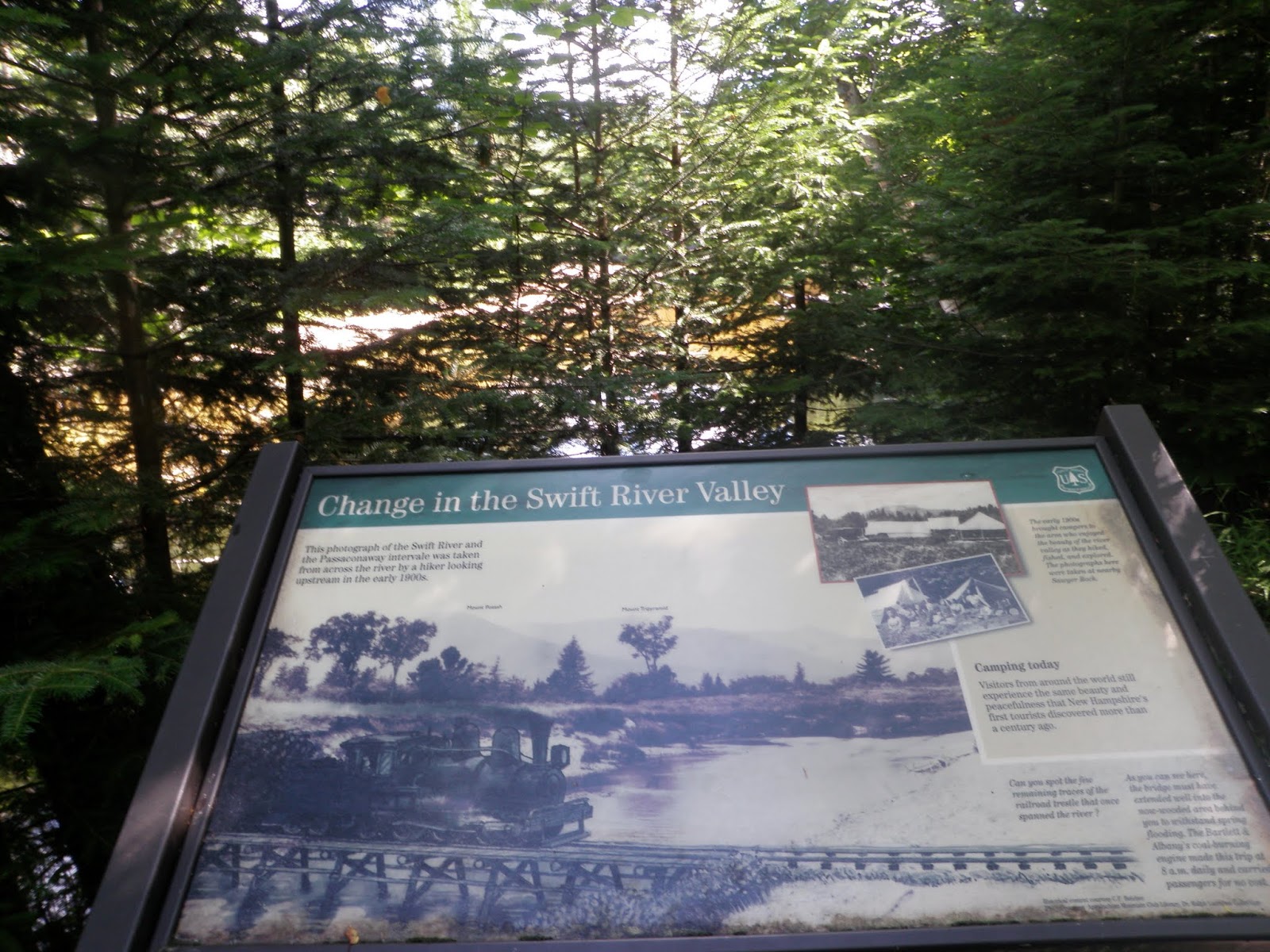
The Swift River as we are near an old train trestle that spanned it.

Small-scale logging on the Bartlett & Albany Railroad.

A long tradition of small-scale logging in Passaconaway.

Before we knew it, we were done with the hike and back at the car. It's a pretty short and simple hike. I barely felt like I didn't have my boots on for this one and I almost did our next hike with my flip-flops on but thought against it as there was a bit more elevation gain, plus I would definitely look like a tourist as there would be more people around.
It was nice seeing the history displayed on the interpretive panels on a few of these hikes, but we needed some hikes with a little substance. Flat and short hikes are good, especially in summer when the heat and humidity can really hit you hard. Something with views would hit the spot.
We made the short drive past Bear Notch Road, and made our way to the Rocky Gorge Scenic Area where this is a large parking area. We would be doing yet another loop hike, which seems to be the theme for the day.
Lovequist Loop
Mileage: 1.15 miles
Elevation gain: 315 feet
Trails used: Lovequist Loop.
Highlight(s): Rocky Gorge, Falls Pond.
Type of Hike: Trailed.
Views: Yes
Hike number four was yet another hike for us to do along the Kancamagus Highway. I believe this next hike is popular, most likely due to the Rocky Gorge Picnic Area and Falls Pond, where you can do some fishing. I am not sure many people do the Lovequist Loop hike, which is located in Albany, New Hampshire, although we did see several people as we hiked it.
When we arrived in the parking area, there were already a few cars there and plenty of people in the water. I switched out my flip-flops for dry shoes for this hike, and after putting on sunscreen we were on our way.


After several more interpretive panels, another hike was in the books, and another hike to go and probably our last. The heat of the day was coming with a vengeance, and I know I was beginning to feel it. I was also reaching a point where I started feeling tired and I knew I would hit a wall eventually. Add that to the fact that I didn't want to do too much to interfere with my vacation coming up.
For this last hike, we had been on a section of this trail several years ago when we used the western part of the loop hike to bushwhack to Moat Mountain-West Peak. It was another short drive from the Rocky Gorge Scenic Area to the Boulder Loop Trail head parking area.
We were working on this being our last hike of the day, and the longest one with the most elevation gain. So it would be a test of how well I(and my knee) would hold up for this hike. I knew the elevation gain would be close to if not more than 1000 feet of elevation gain, but since we weren't in any hurry we could take our time and enjoy the last few miles for the day.
The Boulder Loop Trail is in Albany, New Hampshire and makes a nice steady loop hike to some ledges with decent views and blueberries (in season). There were quite a few cars at the trailhead parking area when we arrived, and we passed several people along the way. By the time we made it to the ledges, people were picking blueberries and there were quite a few people on the various ledges.
We left our wet shoes and socks on the top of Brian's car so they could dry out some, and headed to start the hike.


After we sat on the ledges, and had our fill of blueberries, we did the last section of the Boulder Loop Trail and were back to the cars in decent time. I believe we were back in Lincoln around two p.m. and made a stop to see Steve Smith at the Mountain Wanderer.
This is exactly what I needed for hikes. Although my knee was bothering me slightly as we descended, for the most part, it held up well throughout the day. We managed to red line a few trails we have never done before, but always passed by on the way to different other hikes/trails and the weather was just perfect (cool breeze/mostly sunny but not too hot).
Hike number four was yet another hike for us to do along the Kancamagus Highway. I believe this next hike is popular, most likely due to the Rocky Gorge Picnic Area and Falls Pond, where you can do some fishing. I am not sure many people do the Lovequist Loop hike, which is located in Albany, New Hampshire, although we did see several people as we hiked it.
When we arrived in the parking area, there were already a few cars there and plenty of people in the water. I switched out my flip-flops for dry shoes for this hike, and after putting on sunscreen we were on our way.
We followed a paved walkway from the Rocky Gorge Picnic area parking area to this bridge across Rocky Gorge.

The views looking into Rocky Gorge from the bridge. There were quite a few people here enjoying the water on a nice sunny day.

The power of water and ice.

The junction of the Lovequist Loop/Nanamocomuck Ski Trail and short path to Falls Pond. We turned right to make the loop around Falls Pond.

The Lovequist Loop is easy to follow, but it has quite a few ups and downs as it goes around Falls Pond.

The Pond Community. Table Mountain is just sticking up above Falls Pond, where people can do some fishing.

A better shot of Rocky Gorge on our way out and back to the cars.

After several more interpretive panels, another hike was in the books, and another hike to go and probably our last. The heat of the day was coming with a vengeance, and I know I was beginning to feel it. I was also reaching a point where I started feeling tired and I knew I would hit a wall eventually. Add that to the fact that I didn't want to do too much to interfere with my vacation coming up.
For this last hike, we had been on a section of this trail several years ago when we used the western part of the loop hike to bushwhack to Moat Mountain-West Peak. It was another short drive from the Rocky Gorge Scenic Area to the Boulder Loop Trail head parking area.
Boulder Loop
Mileage: 3.0 miles
Elevation gain: 1065 feet
Elevation gain: 1065 feet
Trails used: Boulder Loop Trail.
Highlight(s): blueberries (in season), views from ledges.
Type of Hike: Trailed.
Views: Yes
We were working on this being our last hike of the day, and the longest one with the most elevation gain. So it would be a test of how well I(and my knee) would hold up for this hike. I knew the elevation gain would be close to if not more than 1000 feet of elevation gain, but since we weren't in any hurry we could take our time and enjoy the last few miles for the day.
The Boulder Loop Trail is in Albany, New Hampshire and makes a nice steady loop hike to some ledges with decent views and blueberries (in season). There were quite a few cars at the trailhead parking area when we arrived, and we passed several people along the way. By the time we made it to the ledges, people were picking blueberries and there were quite a few people on the various ledges.
We left our wet shoes and socks on the top of Brian's car so they could dry out some, and headed to start the hike.
We parked at a parking area for the Boulder Loop Trail off of Passaconaway Road. We did a section of this hike several years ago when we did Moat Mountain-West Peak.

At the junction of the Boulder Loop Trail, we went right to complete that little section of the trail we had not done previously. We came across this rock with nice scorch marks.

It gets fairly steep as you climb the Boulder Loop Trail to the ledges. This is right around where I (personally) started to slow down.

A short spur path leads to ledges with views of South Moat Mountain and Middle Moat Mountain. There were plenty of blueberry bushes up here and plenty of people picking them.

The Boulder Loop ledge views looking towards Blue Mountain, one of the Three Sister peaks, Mount Chocorua, Mount Paugus, Hedgehog Mountain, Mount Potash and the Tripyramids.


Walking back on the opposite side of the Boulder Loop Trail, as it runs besides this recent logging cut.

After we sat on the ledges, and had our fill of blueberries, we did the last section of the Boulder Loop Trail and were back to the cars in decent time. I believe we were back in Lincoln around two p.m. and made a stop to see Steve Smith at the Mountain Wanderer.
This is exactly what I needed for hikes. Although my knee was bothering me slightly as we descended, for the most part, it held up well throughout the day. We managed to red line a few trails we have never done before, but always passed by on the way to different other hikes/trails and the weather was just perfect (cool breeze/mostly sunny but not too hot).
Why no more posts since a year a go?
ReplyDeletePlease keep them coming.....
very nice location thanks for sharing great place for fun and hiking
ReplyDeletehttp://www.trailtosummit.com/winter-hiking-gear/