Elevation gain: 1445 feet
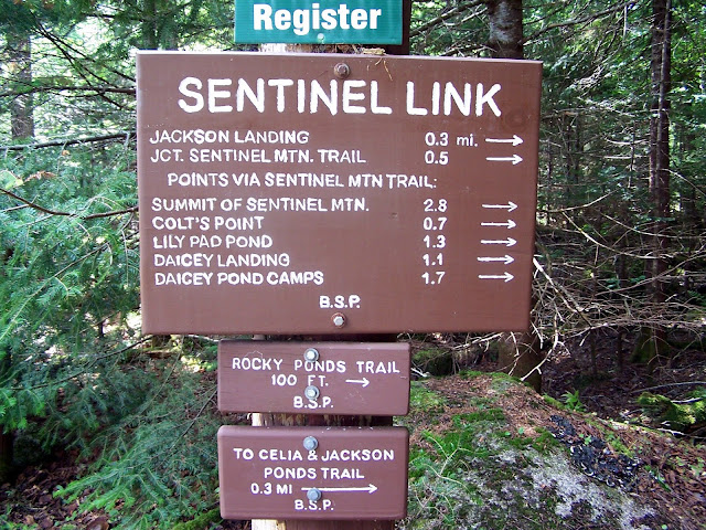
Trails used: Sentinel Link, Sentinel Mountain Trail, Sentinel Loop Trail.
Highlight(s): Baxter State Park, Kidney Pond, views from the ledges around the summit of Sentinel Mountain.
My original idea would be Desi and I doing the Doubletop Mountain's in Baxter State Park, but after our tiring hike up Mount Katahdin, I knew Desi and Becky would be sore. Joe wanted to do this mountain, possibly on Sunday when Desi, Becky and I did Mount Katahdin and Hamlin Peak as his knee was bothering him and he was also healing from an ankle fracture.
Alas, he was spent from hiking to and from Chimney Pond on Sunday so we waited until Monday to do this hike. He was going to go solo at first but I was still feeling good despite the hard hike the day before, so I joined him for this hike. Desi and Becky would do some hiking around the various ponds in the area and would not be joining us for this hike. It was hot and humid when we started this hike and the mosquitoes were buzzing like crazy.
Sentinel Mountain is located in the T3 R10 Wels Township and in Baxter State Park. It stands to the southwest corner of Baxter State Park and offers good views to the west side of Mount Katahdin and the surrounding peaks in the area from the ledges around the summit area.
Kidney Pond - Daicey Pond Trails
Baxter State Park website
The trailhead parking area for Sentinel Mountain, which starts in the Kidney Pond Campground. There is a good sized parking area for roughly 10+ vehicles.
The first half mile of trail, the Sentinel Link, goes around the edge of Kidney Pond and is rocky and rough which slowed Joe down a bit.
The summit of Mount Katahdin was in the clouds early as we got this view of the peak from the shores of Kidney Pond.
The impressive view of Doubletop Mountain from the shores of Kidney Pond.
At the junction of the Sentinel Mountain Trail and Sentinel Link. It would be a 2 mile hike of minor ups and downs before the Sentinel Mountain Trail got steep towards the summit.
The Sentinel Mountain Trail has quite a few ups and downs along the trail and it didn't really make much sense why they built the trail this way. Going through woods like this makes up for it though.
There was quite a few neat rocky areas like this, where boulders that came down from the mountain are now overgrown by trees and vegetation.
The last rocky push towards the summit area of Sentinel Mountain. It seemed like the last half mile was the steepest part of this climb.
We took the left branch of the Sentinel Loop Trail and got these views of Jo-Mary Mountain, Saddleback Mountain (the 2000 foot peak), Little Boardman and Big Boardman Mountain, Big Shanty Mountain, Little Spruce Mountain, Whitecap Mountain, and Hay Mountain from the eastern ledges of Sentinel Mountain.
Big Spencer Mountain and Little Spencer Mountain in the distance, from some ledges on the southwest side of Sentinel Mountain.
The views looking towards Doubletop Mountain and Squaws Bosom Mountain from the Sunset Ledge view area just below the summit of Sentinel Mountain.
The views looking towards Mount O-J-I and Barren Mountain (behind the tree top) from the Sunset Ledge view area just below the summit of Sentinel Mountain.
The short spur path to the Sunset Ledge views, where the two pictures above were taken.
We got the best views from the northern ledges around the summit of Sentinel Mountain of Mount Katahdin, which is out of the clouds. The Owl sits right in between Barren Mountain and Mount Katahdin and just off of Witherle Ravine.
More views from the northern ledges around the summit of Sentinel Mountain of Doubletop Mountain, Mount O-J-I and Mount Coe.
At the Sentinel Loop Trail and Sentinel Mountain Trail junction. It is about half a mile of ledge walk around the summit of Sentinel Mountain (elevation: 1870 feet).
The variation in trees, terrain and vegetation made this an interesting woods hike, even if the Sentinel Mountain Trail was a bit of a pain.
There were several sections, mainly towards the start of the Sentinel Mountain Trail, where there were bog bridges placed so be careful of your footing. There was one fairly good sized stream crossing that was easy to rock hop, but could be difficult during periods of high water.
The final view of Mount Katahdin from the shores of Kidney Pond on our way back to the car.
A nice hike to end our short stay in Baxter State Park. It was hot and humid when we started and it only seemed to get worse as the hike went along but the views from the summit and around the pond made this worth the effort. I think if Joe had been in better condition, I probably could have managed to convince him to do the Doubletop Mountain hike, which is what I originally had as a potential day two hike. This is a good alternative to the hectic areas of the park as we saw only two people total for this whole hike.


No comments:
Post a Comment