We knew the woods would be wet from the rain the night before but I don't think either one of us was prepared for just how wet the woods, logging roads, and logging cuts really were. The bugs also posed a problem for the better part of the day as well. I managed to pick up five more ticks and we found two more on Brian's side of the car, that could still have come from me.
Cow Mountain
Mileage: 3.8
Elevation gain: 735 feet
Trails used: none. ATV trail, logging cuts, bushwhack.
Highlight(s): logging road/ATV road hiking, views from the summit.
We decided to do this one first instead of Aziscohos Mountain for a number of reasons. First, it was along the way to Azischohos Mountain and second, Brian had checked out Google Earth the night before and thought he saw a road that went somewhat close to the summit of Cow Mountain. We would just have to navigate up Neville Brook Road to see how close we could get and if this road truly existed. I managed to get my car as far as the junction of Neville Brook Road and Grass Road. From there on out, it would be a road walk and bushwhack through wet woods and recent logging cuts.
Cow Mountain is located in Dummer, New Hampshire and is the highest point in Dummer. There are no trails that reach its summit so it was a mixture of ATV trails, old logging cuts and a short bushwhack. There are decent views from the summit of Cow Mountain, as well as from the logging cuts leading to and from the summit area.
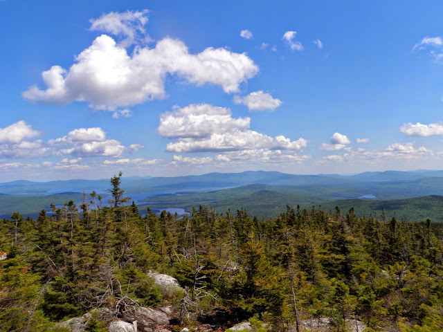
It turns out the tracks Brian saw on Google Earth were there; they were just buried under the vegetation that has grown over it the last year or two. While it wasn't a total loss since we made the summit, it delayed us quite a bit. We even got some nice views which we weren't expecting.
Once we were done with this hike, we bypassed doing anymore peaks in the area so we could head over to Aziscohos Mountain to do a trailed hike now.
Highlight(s): logging road/ATV road hiking, views from the summit.
We decided to do this one first instead of Aziscohos Mountain for a number of reasons. First, it was along the way to Azischohos Mountain and second, Brian had checked out Google Earth the night before and thought he saw a road that went somewhat close to the summit of Cow Mountain. We would just have to navigate up Neville Brook Road to see how close we could get and if this road truly existed. I managed to get my car as far as the junction of Neville Brook Road and Grass Road. From there on out, it would be a road walk and bushwhack through wet woods and recent logging cuts.
Cow Mountain is located in Dummer, New Hampshire and is the highest point in Dummer. There are no trails that reach its summit so it was a mixture of ATV trails, old logging cuts and a short bushwhack. There are decent views from the summit of Cow Mountain, as well as from the logging cuts leading to and from the summit area.
We got some views from this old logging landing of the lower string of wind turbines from the Granite Reliable Wind Farm in Millsfield, New Hampshire.
Brian checking out a map at an ATV junction and the Cow Mountain Trail. While we were hopping this is the tracks he saw going up to the summit of Cow Mountain, it turned out not to be the case. So we had to bushwhack after a brief road walk.
We ended up taking a few recent logging cuts up towards the summit of Cow Mountain.
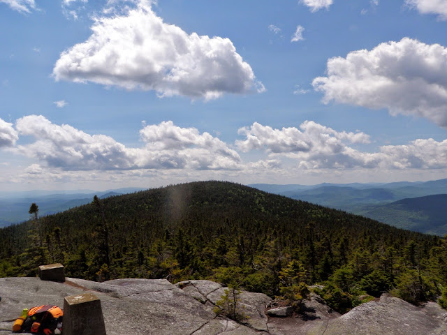
Looking to the Whitcomb Mountains from the summit of Cow Mountain (elevation: 2289 feet).
Views of the Long Mountain Range from the summit of Cow Mountain.
We could even see the Presidential Range and Mount Washington from the summit of Cow Mountain. It's nice when they have done logging on summits.
On the way back down to the car, we found this moose skull as well as several pieces of bone. A neat find for sure.
As we were walking down a logging cut back down to the ATV trail, we got views of Mount Patient, Mount Metalak and Signal Mountain.
Heading back down to the car, and the last shot of Grass Road which is an ATV trail.
It turns out the tracks Brian saw on Google Earth were there; they were just buried under the vegetation that has grown over it the last year or two. While it wasn't a total loss since we made the summit, it delayed us quite a bit. We even got some nice views which we weren't expecting.
Once we were done with this hike, we bypassed doing anymore peaks in the area so we could head over to Aziscohos Mountain to do a trailed hike now.
Aziscohos Mountain
Mileage: 5.5
Elevation gain: 1885 feet
Trails used: Northeast Trail, bushwhack, North Trail.
Highlight(s): 360 degree views, old fire tower remains on the summit.
Highlight(s): 360 degree views, old fire tower remains on the summit.
After our first hike with mixed results (we did summit so that counts for something, the route finding? not so much) the only hike Brian wanted to do, since we were pretty much near by, was Aziscohos Mountain. The reason being is that it once held a fire tower (removed in 2004) but it still has almost 360 degree views from its lower summit.
Apparently the "trail" mentioned in the old Maine Mountain Guide that Brian had with him used to be there and with a little digging online, it looked to me that it was not maintained anymore as it is not listed in the most recent edition of the AMC Maine Mountain Guide.
Aziscohos Mountain is located in Lincoln Plantation, Maine. There was a fire tower on Low Aziscohos Mountain but it was taken down in 2004. There are still numerous good 360 degree views from its bald summit that was burned in a wild fire years ago. There is a trail that comes up to the lower summit but to reach the other summit it requires a pretty gnarly bushwhack across the ridge.
Aziscohos Mountain is located in Lincoln Plantation, Maine. There was a fire tower on Low Aziscohos Mountain but it was taken down in 2004. There are still numerous good 360 degree views from its bald summit that was burned in a wild fire years ago. There is a trail that comes up to the lower summit but to reach the other summit it requires a pretty gnarly bushwhack across the ridge.
We parked at this gate off of Route 16, which is where the old Northeast Trail is located.
The lupines were in bloom as we walked along the Northeast Trail, which was more logging road than trail but it would get worse.
The guide was pretty spot on to this point as we crossed this old rotted bridge along the Northeast Trail. The grass was starting to get overgrown but there was still a distinct trail.
Another water crossing but a harder one to cross as the water was flowing nicely. We still managed to cross and only getting slightly wet.
Yes, Brian is reading the guide book but this is where the book failed us. Since it was almost ten years old, what once held a fire wardens trail was now reduced to old logging cuts. We picked the wrong one to go up.
We headed up towards the higher of the two summits of Aziscohos Mountain through mostly open woods down low, and then things got interesting as we approached the summit.
The summit of Aziscohos Mountain (elevation: 3180 feet) has this mysterious sign as well as a jar. It was thick getting here and since we expected a trailed hike, we were wearing shorts.
We signed into the register quickly as the mosquitoes were pretty thick and we were still about a half mile from the other summit, Low Aziscohos Mountain. Our legs were pretty much shredded worse than when we did The Captain (also done in shorts).
Some general information on the history of the fire tower on Aziscohos Mountain. I think this sign has seen better days.
Funny, the signs elevation is incorrect. Both summits of Azischohos Mountain are roughly about 3180 feet tall.
The old fire tower concrete footings on Low Aziscohos Mountain (elevation: 3180 feet). The fire tower was removed in 2004 but there are still really nice views without it.
We could see Mount Washington, Carter Dome, The Mahoosuc Range and the Baldpates looking to the south from the summit of Low Aziscohos Mountain.
Black Mountain, East Kennebago, the Bigelow Range, Crocker Mountain, Mount Redington, Sugarloaf Mountain, and Saddleback Mountain/The Horn could all be seen to the east from the summit of Low Aziscohos Mountain.
Looking into western Maine at Jackson Mountain/Little Jackson, Tumbledown Mountain, Bemis Mountain and Elephant Mountain from the summit of Low Aziscohos Mountain.
Looking northwest towards Magalloway Mountain, Stub Hill and Rump Mountain from the summit of Low Aziscohos Mountain.
Looking into northeast Maine from the summit of Aziscohos. I can't even begin to name all the peaks that are in most of these photos. They say (on a good day) that you can see fifteen lakes from this summit.
The wooded summit of Aziscohos Mountain, which is a half mile away.
Heading down the North Trail, which heads back down to Route 16. It was like a flowing river in some spots as we made our way down.
Another view of Magalloway Mountain from the North Trail and the site of an old logging cut.
In some spots along the North Trail, especially the lower we got, seemed like it was grown in and extremely muddy. I would imagine it would be a nicer snowshoe hike.
Once back down to Route 16, we had to make an almost one mile road walk back to the car. Funny thing is, where the Aziscohos Mountain Trail sign is right where we turned around to go back to the old trail head. Lessons learned. The bugs were kept at bay as we sat on the summit and enjoyed the views but were back to being pretty fierce as we hiked back down and out to the car. I would have enjoyed this one more with better information and less bugs but you can't win them all.
This concluded our days hike. We still had a roughly 2.5 hour drive to get back to the park n' ride so we bypassed anymore hikes so we could get home at a decent time.


No comments:
Post a Comment